Maps of East Sussex England
Home > Maps of England > East Sussex Maps
Welcome to our East Sussex map page. The map of East Sussex England that is located below is provided by Google Maps. You can "grab" the electronic map and move it around to re-center the map. You can change between standard map view and satellite map view by clicking the small square on the bottom left-hand corner of the map. Satellite map view utilises orbiting satellite and / or aerial high-resolution photography to display images of the map location to street level detail (really quite amazing). Standard map view shows a traditional street map (also known as a road map). You can use the zoom buttons on the bottom right-hand side of the map to zoom in or out to street level detail. We have digital online maps for most towns and cities on the Maps of England page. We also have a good collection of old school printable maps on the Maps of England page.
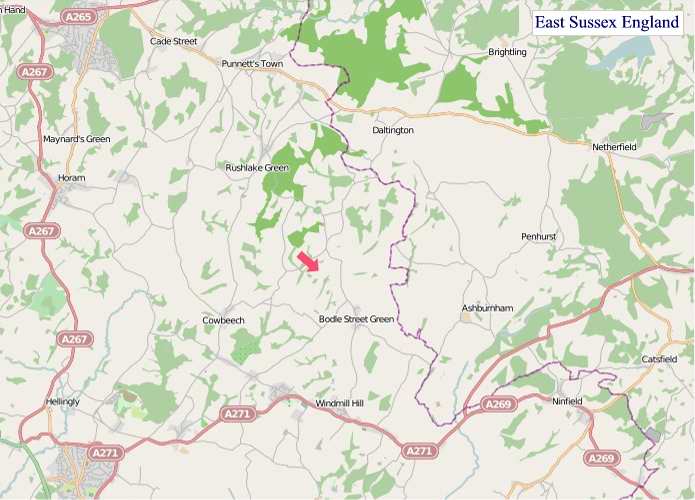
A map of East Sussex, England
East Sussex Maps
I hope you like the East Sussex County, England street map / road map situated above.
If you like our website, please consider adding a link to the site. These links help to build website traffic and they are considered a vote of confidence for a site.
East Sussex
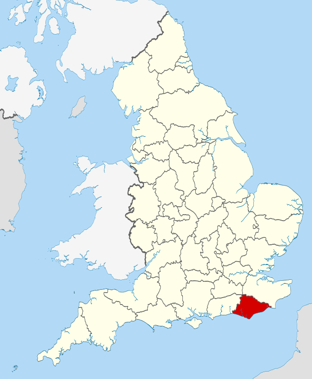
East Sussex is a county in South East England. It is bordered by the counties of Kent to the north and east, West Sussex to the west, and Surrey for a short distance to the north-west, as well as the English Channel to the south.
History
East Sussex is part of the historic county of Sussex, which has its roots in the ancient kingdom of the South Saxons, who established themselves there in the 5th century AD, after the departure of the Romans. Archaeological remains are plentiful, especially in the upland areas. The area's position on the coast has also meant that there were many invaders, including the Romans and later the Normans. Earlier industries have included fishing, iron-making, and the wool trade, all of which have declined, or been lost completely.
Governance
Sussex was historically sub-divided into six rapes. From the 12th century the three eastern rapes together and the three western rapes together had separate quarter sessions, with the county town of the three eastern rapes being Lewes. This situation was formalised by Parliament in 1865, and the two parts were made into administrative counties, each with it own elected county council in 1889 under the Local Government Act 1888. In East Sussex there were also three self-administered county boroughs: Brighton, Eastbourne and Hastings.
In 1974 East Sussex was made a non-metropolitan and ceremonial county, and the three county boroughs became districts within the county. At the same time the western boundary was altered, so that the Mid Sussex region (including Burgess Hill and Haywards Heath) was transferred to the county of West Sussex. In 1997, Brighton and Hove became a self-administered unitary authority; it was granted city status in 2000, whilst remaining part of the ceremonial county of East Sussex.
The area of East Sussex County Council's jurisdiction is divided into five local government districts. Three are large rural districts (from west to east): Lewes, Wealden, and Rother. Eastbourne and Hastings are mainly urban areas. The rural districts are further subdivided into civil parishes.
Settlements
The location of settlements in East Sussex has been determined both by its history and its geography. The original towns and villages tended to be where its economy lay: fishing along the coast and agriculture and iron mining on the Weald. Industry today tends to be geared towards tourism, and particularly along the coastal strip. Here towns such as Bexhill-on-Sea, Eastbourne, and Hastings lie. Newhaven and Rye are ports, although the latter is also of historical importance. Peacehaven and Seaford are more dormitory towns than anything else. Away from the coast lie former market towns such as Hailsham, Heathfield and Uckfield; Crowborough is a centre for the Ashdown Forest. Lewes, the County town of East Sussex; and Battle, with its Norman Conquest beginnings, and Wadhurst are the other three towns of significance.
From Wikipedia, the free encyclopedia
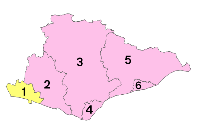
Districts of East Sussex
1 - City of Brighton and Hove
2 - Lewes
3 - Wealden
4 - Eastbourne
5 - Rother
6 - Hastings
"© OpenStreetMap contributors, CC BY-SA".


