London Underground Tube Map
District Line
Home > Maps of England > District Line Map
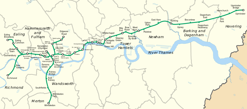
The District line is a London Underground line that runs from Upminster in the east and Edgware Road in the west to Earl's Court in west London, where it splits into a number of branches. One branch runs to Wimbledon in south-west London and a short branch, with a limited service, only runs for one stop to Kensington (Olympia). The main route continues west from Earl's Court to Turnham Green after which it divides again into two western branches, to Richmond and Ealing Broadway.
Coloured green on the Tube map, the line serves 60 stations (more than any other Underground line) over 40 miles (64 km). It is the only Underground line to use a bridge to traverse the River Thames, crossing on both the Wimbledon and Richmond branches. The track and stations between Barking and Aldgate East are shared with the Hammersmith & City line, and between Tower Hill and Gloucester Road and on the Edgware Road branch they are shared with the Circle line. Some of the stations between South Kensington and Ealing Common are shared with the Piccadilly line. Unlike London's deep-level lines, the railway tunnels are just below the surface, and the trains are of a similar size to those on British main lines.
The District line is the busiest of the sub-surface lines and the fifth-busiest line overall on the Underground, with over 208 million passenger journeys recorded in 2017/18.
The original Metropolitan District Railway (as it was then called) opened in December 1868 from South Kensington to Westminster as part of a plan for a below-ground "inner circle" connecting London's main line termini. At first, services were operated using wooden carriages hauled by steam locomotives. Electrification was financed by the American Charles Yerkes, and electric services began in 1905. The railway was absorbed by the London Passenger Transport Board in 1933. In the first half of the 1930s the Piccadilly line took over the Uxbridge and Hounslow branches, although a peak-hour District line service ran on the Hounslow branch until 1964. Kensington (Olympia) has been served by the District line since 1946, and a short branch to South Acton closed in 1959. The trains carried guards until one-person operation was introduced in 1985.
The signalling system is being upgraded, and the previous D Stock trains were replaced by seven-car S Stock trains in 2017.
From Wikipedia, the free encyclopedia
This file is licensed under the Creative Commons Attribution-Share Alike 3.0 Unported license.
London Underground Overground DLR Crossrail Map
Music


