A large detailed map of Cumbria, England
Explore Cumbria with an interactive map featuring Street View, satellite and terrain views. Live weather, local news and location details for Cumbria — plus links to detailed street maps for cities, towns, villages and hamlets across the county.
Cumbria County Map
Map search is available for a limited number of queries per session to manage costs. Be specific — search precisely for best results.
| County Town | Carlisle |
| Region | North West England |
| Country | England |
| Status | Ceremonial county |
| Area | 6,768 km² |
| Population | 502,000 |
| Latitude | 54.5883 |
| Longitude | -2.9879 |
| Cities & Towns | 1,079 |
| Locality Maps | Locality Maps |
About Cumbria
Jagged peaks, stark and raw, claw at the sky above valleys carved by ancient ice, a wild amphitheatre of rock and heather. The restless Lake District, a jewel of England, shelters deep waters like Windermere and Ullswater, their surfaces mirroring the dramatic fells that rise and fall in endless, undulating waves. Where the land relents, silver ribbons of rivers, the Eden and the Derwent, wind their way towards the often-turbulent Irish Sea, their estuaries embracing a coastline of shifting sands and brooding cliffs. This is a landscape of elemental power, where wind and water sculpt the very soul of the earth.
Echoes of Roman legions linger in Hadrian's Wall, a stony testament to imperial ambition that marches across the northern reaches, a silent sentinel of centuries past. Later, Viking longships may have graced its shores, leaving their mark on placenames and hardy bloodlines, while monastic orders built their sanctuaries amidst the seclusion of these northern hills. The industrial revolution, too, left its imprint, transforming mining towns and bringing new life to ports like Whitehaven, yet the ancient spirit of Cumbria, forged in peace and conflict, endures.
Hardy sheep graze the steepest inclines, their wool a dependable staple that has sustained generations of shepherds and weavers, a quiet cornerstone of the Cumbrian economy. Quarrying, for slate and stone, has long been a vital enterprise, shaping the very buildings and walls of its villages, whilst more modern manufacturing, from advanced engineering in Barrow-in-Furness to specialist food production, adds a contemporary layer to its economic tapestry. Tourism, drawn by the sheer magnificence of its natural beauty, now provides a significant, and often cherished, livelihood for many.
A quiet resilience, a deep-rooted connection to the land, characterises the Cumbrian folk, their speech often carrying the lilt of generations. They are a people who understand the seasons, the vagaries of the weather, and the enduring strength of community, their traditions woven into the fabric of agricultural shows and local festivals. Artists and poets, from Wordsworth to Beatrix Potter, have found inspiration in these dramatic vistas, capturing a unique spirit that continues to draw souls seeking solace and inspiration in this wild and beautiful corner of England.
Districts of Cumbria
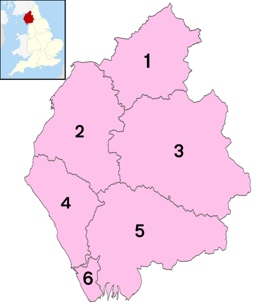
1 - City of Carlisle
2 - Allerdale
3 - Eden
4 - Copeland
5 - South Lakeland
6 - Barrow-in-Furness
From Wikipedia, the free encyclopedia
Cumbria City and Town Maps
A
B
C
D
E
F
G
H
J
K
L
M
N
O
P
R
S
T
U
W
Cumbria Maps — Interactive Map, Street View, Weather & News
This page provides an interactive Google map of Cumbria, England with Street View, satellite and terrain views, alongside links to detailed street maps for cities, towns, villages and hamlets across the county. Cumbria sits within the North West England region.
Every locality map page includes an embedded street and satellite map together with live weather where available — current conditions with hourly and 7-day outlooks powered by Open-Meteo. Local and world news feeds — including BBC News — keep pages current, and Wikipedia summaries provide additional local context.
Location data is sourced from OS Open Names © Crown copyright and database rights 2024, Ordnance Survey, Open Government Licence v3.0, and verified by coordinates rather than name matching alone.