A large detailed map of East Riding of Yorkshire, England
Explore East Riding of Yorkshire with an interactive map featuring Street View, satellite and terrain views. Live weather, local news and location details for East Riding of Yorkshire — plus links to detailed street maps for cities, towns, villages and hamlets across the county.
East Riding of Yorkshire County Map
Map search is available for a limited number of queries per session to manage costs. Be specific — search precisely for best results.
| County Town | Beverley |
| Region | Yorkshire and the Humber |
| Country | England |
| Status | Ceremonial county |
| Area | 2,479 km² |
| Population | 607,000 |
| Latitude | 53.8536 |
| Longitude | -0.4793 |
| Cities & Towns | 381 |
| Locality Maps | Locality Maps |
About East Riding of Yorkshire
Undulating wolds, a gentle swell of chalky earth, define the heart of this county, giving way to the vast, shimmering expanse of the Humber Estuary and the rugged, wind-battered coastline where the North Sea gnaws at the land. Rivers like the Hull and the Derwent carve languid paths through fertile plains, their waters reflecting the vast, often dramatic skies that preside over this easternmost reach of Yorkshire. The natural character here is one of subtle beauty, a landscape of wide horizons and ancient, enduring patterns, where the land itself seems to breathe with the slow rhythm of the seasons.
Echoes of Roman legions still resonate in the earth, remnants of their roads and settlements hinting at an ancient dominion over these lands, followed by the Anglo-Saxon migrations that shaped its early identity. Viking raids left their mark, their influence subtly woven into the place names and the very spirit of the people, before the Norman Conquest brought imposing castles and a new order. Later centuries witnessed the rise of market towns like Beverley, a centre of monastic power and pilgrimage, and the industrial stirrings that would eventually transform its coastal ports.
Agriculture remains the bedrock, its vast fields yielding bountiful harvests of grain and sugar beet, a testament to the enduring fertility of the soil. Across the Humber, the docks of Hull, though now largely repurposed, recall a time of vigorous trade and shipbuilding, while inland, smaller manufacturing enterprises still practise their crafts. The region’s economy, while modernised, retains a connection to its agrarian roots, a quiet industriousness that underpins its daily existence.
A stoic pragmatism often characterises the folk of the East Riding, their conversations seasoned with a dry wit and a deep-seated connection to their homeland. Traditions persist in the bustling market days of Driffield and the seaside amusements of Bridlington, where generations have gathered. The artistic spirit, though perhaps less ostentatious than in some other regions, finds expression in local crafts and a profound appreciation for the enduring beauty of their surroundings, a quiet pride in the East Yorkshire way of life.
East Riding of Yorkshire Maps
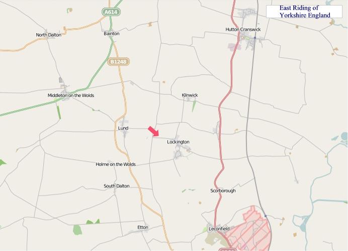
"© OpenStreetMap contributors, CC BY-SA".
From Wikipedia, the free encyclopedia
East Riding of Yorkshire City and Town Maps
A
B
C
D
E
F
G
H
K
L
M
N
O
P
R
S
T
W
Y
East Riding of Yorkshire Maps — Interactive Map, Street View, Weather & News
This page provides an interactive Google map of East Riding of Yorkshire, England with Street View, satellite and terrain views, alongside links to detailed street maps for cities, towns, villages and hamlets across the county. East Riding of Yorkshire sits within the Yorkshire and the Humber region.
Every locality map page includes an embedded street and satellite map together with live weather where available — current conditions with hourly and 7-day outlooks powered by Open-Meteo. Local and world news feeds — including BBC News — keep pages current, and Wikipedia summaries provide additional local context.
Location data is sourced from OS Open Names © Crown copyright and database rights 2024, Ordnance Survey, Open Government Licence v3.0, and verified by coordinates rather than name matching alone.