A large detailed map of Gloucestershire, England
Explore Gloucestershire with an interactive map featuring Street View, satellite and terrain views. Live weather, local news and location details for Gloucestershire — plus links to detailed street maps for cities, towns, villages and hamlets across the county.
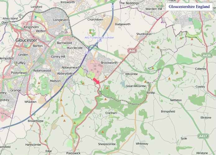
Gloucestershire County Map
Map search is available for a limited number of queries per session to manage costs. Be specific — search precisely for best results.
| County Town | Gloucester |
| Region | South West England |
| Country | England |
| Status | Ceremonial county |
| Area | 3,150 km² |
| Population | 955,000 |
| Latitude | 51.6642 |
| Longitude | -2.3421 |
| Cities & Towns | 1,355 |
| Locality Maps | Locality Maps |
About Gloucestershire
Verdant swells of the Cotswolds rise like sleeping giants, their ancient limestone bones softened by emerald cloaks of pasture and beech woods, a landscape sculpted by millennia of wind and water. The River Severn, a broad, silver serpent, carves its majestic path through the county, its tidal reaches embracing the rich Severn Vale, while the River Wye whispers secrets along its western fringe, its course marked by dramatic gorges and ancient woodlands. Beyond these flowing arteries, rolling hills undulate towards the Malvern Hills on the north-eastern border, their distinctive contours offering panoramic vistas, a testament to the gentle, yet persistent, hand of nature upon this corner of England.
Echoes of Roman legions linger in the tessellated floors of Cirencester's villas, a testament to the county's early importance, whilst Saxon charters speak of burgeoning settlements and land grants. Gloucester, a city of formidable Roman walls and a cathedral of soaring ambition, bore witness to the decisive Battle of Tewkesbury in 1471, a brutal chapter in the Wars of the Roses. Later centuries saw the rise of market towns like Stroud and Cheltenham, each developing its own distinct character and economic pulse, reflecting the evolving tapestry of English history from medieval piety to Georgian refinement.
Agriculture remains the lifeblood of Gloucestershire, its fertile soils yielding bountiful crops and supporting a thriving sheep farming tradition that has shaped the very character of the Cotswolds. Beyond the fields, the county harbours a diverse industrial heritage, with Stroud's woollen mills long since giving way to modern manufacturing and engineering enterprises, including the development of aerospace components and specialised machinery. Cheltenham's spa town status has also fostered a significant service economy, attracting businesses and fostering innovation in sectors ranging from technology to tourism, a testament to its enduring appeal.
A spirit of quiet resilience and a deep connection to the land defines the people of Gloucestershire, their traditions woven into the fabric of village life and market days. This is a place where ancient customs, from Morris dancing to harvest festivals, are still observed with genuine affection, reflecting a strong sense of community and continuity. The county has nurtured artists and thinkers, from the Romantic poet Edward Thomas, who found inspiration in its landscapes, to the scientific minds drawn to its universities and research institutions, all contributing to a vibrant cultural tapestry that honours its past whilst embracing the future.
Gloucestershire Maps
"© OpenStreetMap contributors, CC BY-SA".
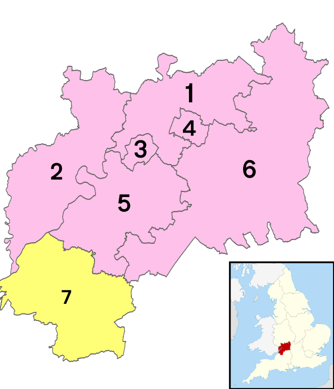
Districts of Gloucestershire
1 - Tewkesbury
2 - Forest of Dean
3 - City of Gloucester
4 - Cheltenham
5 - Stroud
6 - Cotswold
7 - South Gloucestershire
From Wikipedia, the free encyclopedia
Gloucestershire City and Town Maps
A
B
C
D
E
F
G
H
I
J
K
L
M
N
O
P
R
S
T
U
W
Y
Gloucestershire Maps — Interactive Map, Street View, Weather & News
This page provides an interactive Google map of Gloucestershire, England with Street View, satellite and terrain views, alongside links to detailed street maps for cities, towns, villages and hamlets across the county. Gloucestershire sits within the South West England region.
Every locality map page includes an embedded street and satellite map together with live weather where available — current conditions with hourly and 7-day outlooks powered by Open-Meteo. Local and world news feeds — including BBC News — keep pages current, and Wikipedia summaries provide additional local context.
Location data is sourced from OS Open Names © Crown copyright and database rights 2024, Ordnance Survey, Open Government Licence v3.0, and verified by coordinates rather than name matching alone.