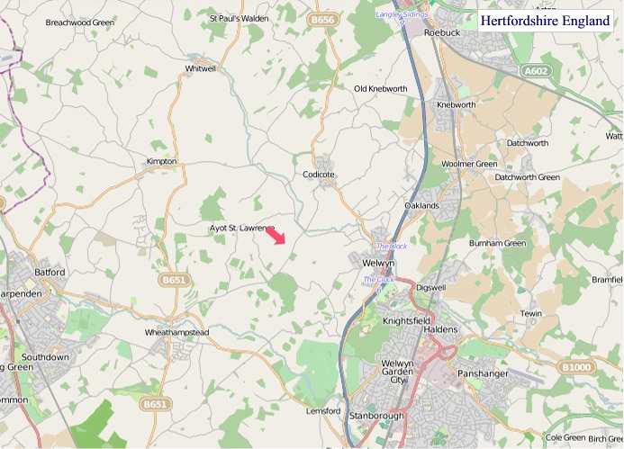
A large detailed map of Hertfordshire, England
Explore Hertfordshire with an interactive map featuring Street View, satellite and terrain views. Live weather, local news and location details for Hertfordshire — plus links to detailed street maps for cities, towns, villages and hamlets across the county.
Hertfordshire County Map
Map search is available for a limited number of queries per session to manage costs. Be specific — search precisely for best results.
| County Town | Hertford |
| Region | East of England |
| Country | England |
| Status | Ceremonial county |
| Area | 1,643 km² |
| Population | 1,198,000 |
| Latitude | 51.8225 |
| Longitude | -0.2277 |
| Cities & Towns | 537 |
| Locality Maps | Locality Maps |
About Hertfordshire
Gently undulating, the terrain of Hertfordshire offers a pastoral tapestry, a gentle rise and fall rather than dramatic peaks, where chalk downs give way to fertile clay vales. The River Lea, a vital artery, meanders through its heart, feeding verdant meadows and carving shallow valleys, whilst the Grand Union Canal, a testament to Victorian industry, bisects the county, its towpaths now trod by walkers and cyclists. Though landlocked, its character is one of quiet, rolling beauty, a landscape shaped by water and time rather than the ruggedness of coastal cliffs or imposing mountain ranges.
Ancient roots run deep within this soil, a testament to Roman occupation when Verulamium, near modern St Albans, thrived as a significant settlement and capital of Britannia. Later, Saxon lords and Norman conquerors left their mark upon its manors and abbeys, and during the Wars of the Roses, Hertfordshire saw skirmishes and royal visits, its proximity to London making it a stage for national drama. The dissolution of the monasteries reshaped its ecclesiastical landscape, while the advent of the railways in the 19th century ushered in a new era of suburban growth and industrial expansion.
Agriculture remains a cornerstone of Hertfordshire's economic life, its loam-rich soils yielding bountiful harvests of cereals and root vegetables, supporting a proud tradition of farming. Beyond the fields, the county has cultivated a diverse industrial base, with a strong presence in aerospace engineering, particularly around Hatfield where de Havilland once pioneered aviation, and a thriving sector of technology and creative industries in towns like Stevenage. Pharmaceutical manufacturing and logistics also contribute significantly to its economic vitality, showcasing a blend of heritage and innovation.
The people of Hertfordshire, often shaped by their proximity to the metropolis, possess a character that balances pragmatism with a quiet appreciation for their heritage and the surrounding countryside. Traditional fêtes and local markets still draw communities together, preserving customs passed down through generations, whilst the county has nurtured a vibrant arts scene, from the Maltings Theatre in St Albans to smaller galleries showcasing local talent. Way of life here often reflects a blend of suburban comfort and access to rural pursuits, fostering a sense of rootedness and contentedness.
Hertfordshire Maps
"© OpenStreetMap contributors, CC BY-SA".
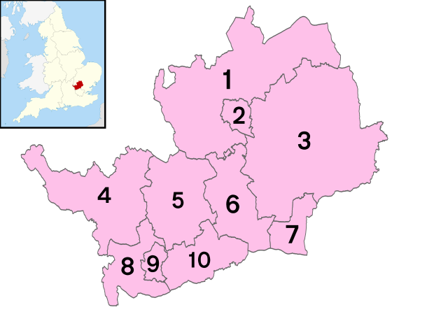
Districts of Hertfordshire
1 - North Hertfordshire
2 - Stevenage
3 - East Hertfordshire
4 - Dacorum
5 - City of St Albans
6 - Welwyn Hatfield
7 - Broxbourne
8 - Three Rivers
9 - Watford
10 - Hertsmere
This file is licensed under the Creative Commons Attribution 3.0 Unported license.
From Wikipedia, the free encyclopedia
Hertfordshire City and Town Maps
A
B
C
D
E
F
G
H
K
L
M
N
O
P
R
S
T
W
Hertfordshire Maps — Interactive Map, Street View, Weather & News
This page provides an interactive Google map of Hertfordshire, England with Street View, satellite and terrain views, alongside links to detailed street maps for cities, towns, villages and hamlets across the county. Hertfordshire sits within the East of England region.
Every locality map page includes an embedded street and satellite map together with live weather where available — current conditions with hourly and 7-day outlooks powered by Open-Meteo. Local and world news feeds — including BBC News — keep pages current, and Wikipedia summaries provide additional local context.
Location data is sourced from OS Open Names © Crown copyright and database rights 2024, Ordnance Survey, Open Government Licence v3.0, and verified by coordinates rather than name matching alone.