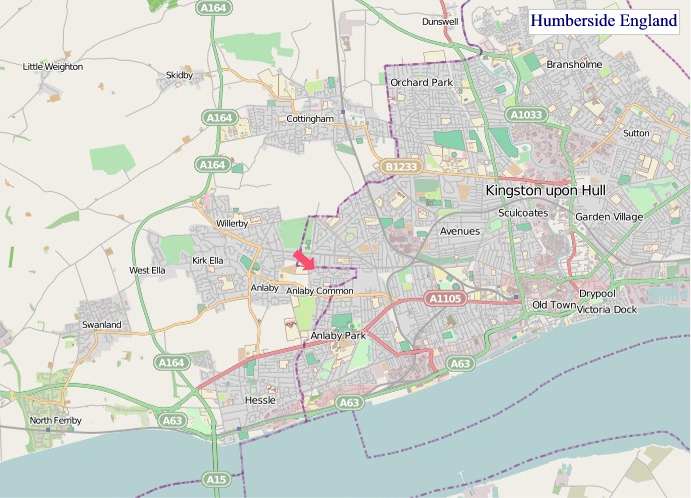
A large detailed map of Humberside, England
Explore Humberside with this interactive street and satellite map. You can “grab” the Humberside map and move it around to re-centre it. You can change between standard map view and satellite map view by clicking the small square in the bottom left-hand corner of the map. You can use the zoom buttons on the lower right side of the map to zoom in or out to street-level detail. You will find links to city and town maps, live weather and local news below.
Humberside County Map
| County Town | Beverley |
| Region | Yorkshire and the Humber |
| Country | England |
| Status | Former county (1974–1996) |
| Area | 3,512 km² |
| Population | 912,000 |
| Latitude | 53.5776 |
| Longitude | -0.4618 |
| Cities & Towns | 153 |
| Locality Maps | Locality Maps |
About Humberside
Vast plains, sculpted by glacial retreat, define this eastern fringe, where the land slopes gently towards the immense estuary. The Humber, a tidal artery, cleaves the landscape, its muddy banks a testament to the ceaseless ebb and flow of the North Sea. To the west, the Lincolnshire Wolds offer a muted, rolling topography, a stark contrast to the flat, fertile expanses of the Vale of York stretching north. Here, the air often carries the saline tang of the coast, a constant reminder of the ocean’s proximity and the raw, elemental power that shapes the coastline.
Echoes of Roman legions linger in the earth, their roads a forgotten grid beneath the modern cartography, particularly around the settlements of Grimsby and Scunthorpe. Medieval abbeys, now spectral ruins, speak of a spiritual age, while the Viking legacy is etched into the very nomenclature of many hamlets. Later centuries saw the rise of market towns and fishing ports, their fortunes tied to the sea and the growing industrial might of the Victorian era, a period that undeniably left its indelible mark upon the region's character.
Agriculture remains a cornerstone, its fields yielding bountiful harvests of grain and sugar beet, a bucolic counterpoint to the industrial heartlands. Hull, once a powerhouse of fishing, now pivots towards advanced manufacturing and renewable energy, a testament to its enduring resilience. Scunthorpe's steel heritage, though diminished, still whispers of its past dominance, while the ports of Grimsby continue to handle significant trade, adapting to the evolving global economy. This blend of the agrarian and the industrial defines the economic sinews of the county.
A stoic pragmatism characterises the people, their humour often as dry as the Yorkshire pudding served on a Sunday. Generations of working the land and the sea have forged a deep connection to place, a quiet pride in their heritage. Traditions of fishing and farming persist, passed down through families, while the arts scene, particularly in Hull, has blossomed, revealing a creative spirit that belies the region’s industrial reputation. Life here moves at a steady, grounded pace, an honest rhythm dictated by the tides and the turning seasons.
Humberside Maps
"© OpenStreetMap contributors, CC BY-SA".
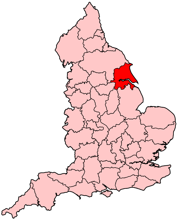
Humberside Location in England Map
Districts of Humberside 1974 to 1996 Map
_numbered.png)
The county was divided into nine non-metropolitan districts:
1 - North Wolds, renamed East Yorkshire in 1981
2 - Holderness
3 - Kingston upon Hull
4 - Beverley, renamed East Yorkshire Borough of Beverley in 1981
5 - Boothferry
6 - Scunthorpe
7 - Glanford
8 - Grimsby, renamed Great Grimsby in 1979
9 - Cleethorpes
From Wikipedia, the free encyclopedia