A large detailed map of Lincolnshire, England
Explore Lincolnshire with an interactive map featuring Street View, satellite and terrain views. Live weather, local news and location details for Lincolnshire — plus links to detailed street maps for cities, towns, villages and hamlets across the county.
Lincolnshire County Map
Map search is available for a limited number of queries per session to manage costs. Be specific — search precisely for best results.
| County Town | Lincoln |
| Region | East Midlands |
| Country | England |
| Status | Ceremonial county |
| Area | 6,959 km² |
| Population | 788,000 |
| Latitude | 53.1300 |
| Longitude | -0.2405 |
| Cities & Towns | 926 |
| Locality Maps | Locality Maps |
About Lincolnshire
Unfurling across the eastern flank of England, Lincolnshire's geography is a study in gentle, undulating plains and a remarkably long, often wild, coastline. The Fens, a vast expanse of reclaimed marshland, dominate the south, a testament to human ingenuity and a land of immense flatness punctuated by drainage dykes and the slow, deliberate flow of rivers like the Witham and the Welland. Further north, the Lincolnshire Wolds offer a subtler, greener beauty, a rolling chalk ridge that provides a welcome, if modest, elevation above the surrounding countryside. The North Sea's relentless embrace shapes the sandy beaches and dramatic cliffs of the coast, a frontier where land meets an ever-shifting horizon.
Echoes of centuries past resonate through Lincolnshire's varied history, from the Roman presence that left its mark in roads and settlements like Lincoln itself, to the medieval grandeur of its cathedrals and abbeys. The county played a significant role during the Wars of the Roses, and later, the agricultural revolution transformed its landscape and rural life. More recently, its airfields became vital hubs during both World Wars, a poignant reminder of more turbulent times. Throughout its existence, Lincolnshire has been a place of quiet resilience, its history written in stone, soil, and the enduring spirit of its inhabitants.
Agriculture remains the beating heart of Lincolnshire's economy, its fertile soils yielding bountiful crops and supporting a thriving livestock industry that feeds the nation. Beyond the fields, however, a robust manufacturing sector has taken root, particularly in areas like Grimsby, where fishing traditions have evolved into a significant food processing industry, and automotive engineering finds a strong foothold. Defence manufacturing also contributes to the county's economic tapestry, providing skilled employment and driving innovation. These diverse enterprises demonstrate a capacity for adaptation and a commitment to practical enterprise.
The people of Lincolnshire are often characterised by a quiet pragmatism and a deep-seated connection to their land, a reflection of the county's enduring agricultural heritage. Their traditions are often rooted in the seasons and the rhythms of rural life, with local festivals and markets serving as vital social anchors. While not always at the forefront of national artistic movements, the county has nurtured its own creative talents, from the poetry of John Clare to the scientific contributions of scientists like Sir Isaac Newton, whose formative years were spent here. The way of life is one of steady endeavour and a profound appreciation for the subtle beauties of their homeland.
Lincolnshire Maps
"© OpenStreetMap contributors, CC BY-SA".
Districts of Lincolnshire
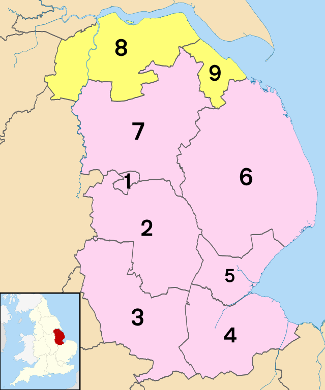
1 - City of Lincoln
2 - North Kesteven
3 - South Kesteven
4 - South Holland
5 - Boston
6 - East Lindsey
7 - West Lindsey
8 - North Lincolnshire
9 - North East Lincolnshire
From Wikipedia, the free encyclopedia
Lincolnshire City and Town Maps
A
B
C
D
E
F
G
H
I
K
L
M
N
O
P
R
S
T
W
Lincolnshire Maps — Interactive Map, Street View, Weather & News
This page provides an interactive Google map of Lincolnshire, England with Street View, satellite and terrain views, alongside links to detailed street maps for cities, towns, villages and hamlets across the county. Lincolnshire sits within the East Midlands region.
Every locality map page includes an embedded street and satellite map together with live weather where available — current conditions with hourly and 7-day outlooks powered by Open-Meteo. Local and world news feeds — including BBC News — keep pages current, and Wikipedia summaries provide additional local context.
Location data is sourced from OS Open Names © Crown copyright and database rights 2024, Ordnance Survey, Open Government Licence v3.0, and verified by coordinates rather than name matching alone.