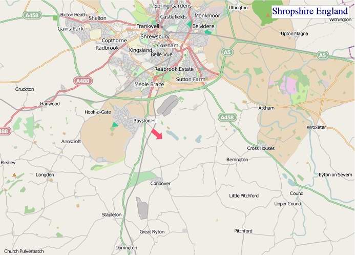
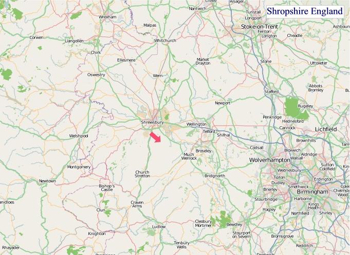
A large detailed map of Shropshire, England
Explore Shropshire with an interactive map featuring Street View, satellite and terrain views. Live weather, local news and location details for Shropshire — plus links to detailed street maps for cities, towns, villages and hamlets across the county.
Shropshire County Map
Map search is available for a limited number of queries per session to manage costs. Be specific — search precisely for best results.
| County Town | Shrewsbury |
| Region | West Midlands |
| Country | England |
| Status | Ceremonial county |
| Area | 3,487 km² |
| Population | 328,000 |
| Latitude | 52.6593 |
| Longitude | -2.7043 |
| Cities & Towns | 1,096 |
| Locality Maps | Locality Maps |
About Shropshire
Undulating hills, like slumbering giants, define Shropshire’s gentle embrace, a tapestry woven with ancient woodlands and fields of emerald. The River Severn, a silver serpent, winds its majestic course through the heart of the county, its banks a verdant testament to nature’s enduring artistry. Beyond these placid waters, the Shropshire Hills Area of Outstanding Natural Beauty offers a more rugged charm, their heather-clad slopes and rocky outcrops hinting at a wilder, untamed spirit. This is a landscape that whispers tales of geological ages, a place where the earth itself seems to breathe.
Centuries of human endeavour have etched their mark upon this ancient soil, from the Roman legions who marched through Wroxeter, a shadow of its former imperial glory, to the medieval fortifications that still guard Ludlow's skyline. The English Civil War saw fierce skirmishes, and the Industrial Revolution, though perhaps less overtly dramatic here than elsewhere, subtly reshaped its rural economy. Indeed, Shrewsbury, with its timber-framed buildings and winding lanes, stands as a living chronicle of successive eras, a constant reminder of those who walked these streets before.
Agriculture, the enduring backbone of Shropshire, continues to thrive, its fertile plains yielding bountiful harvests of grain and its pastoral lands supporting robust livestock. Beyond the fields, a quiet industrial heritage persists, particularly in areas like Telford, where engineering prowess once pulsed through factories producing machinery and ironwork. Though the grand industrial behemoths have largely receded, the spirit of innovation endures in specialised manufacturing and precision engineering, a testament to the county's pragmatic resourcefulness.
Here, a certain quiet dignity pervades the character of the people, a grounded sense of community forged by generations tied to the land and its rhythms. Traditions, from the vibrant agricultural shows to the enduring appeal of rural pubs, remain a cherished part of daily life, fostering a strong sense of local identity. The arts, too, find a receptive audience, with numerous galleries and theatres showcasing local talent and attracting visitors drawn to the county’s understated cultural allure. This is a place where a slower pace of life allows for deeper connections and a profound appreciation for simple pleasures.
Shropshire Maps
"© OpenStreetMap contributors, CC BY-SA".
Districts of Shropshire
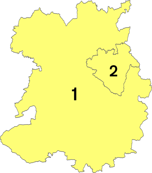
1 - Shropshire
2 - Telford and Wrekin
From Wikipedia, the free encyclopedia
Shropshire City and Town Maps
A
B
C
D
E
F
G
H
I
K
L
M
N
O
P
Q
R
S
T
U
V
W
Y
Shropshire Maps — Interactive Map, Street View, Weather & News
This page provides an interactive Google map of Shropshire, England with Street View, satellite and terrain views, alongside links to detailed street maps for cities, towns, villages and hamlets across the county. Shropshire sits within the West Midlands region.
Every locality map page includes an embedded street and satellite map together with live weather where available — current conditions with hourly and 7-day outlooks powered by Open-Meteo. Local and world news feeds — including BBC News — keep pages current, and Wikipedia summaries provide additional local context.
Location data is sourced from OS Open Names © Crown copyright and database rights 2024, Ordnance Survey, Open Government Licence v3.0, and verified by coordinates rather than name matching alone.