A large detailed map of Tyne and Wear, England
Explore Tyne and Wear with an interactive map featuring Street View, satellite and terrain views. Live weather, local news and location details for Tyne and Wear — plus links to detailed street maps for cities, towns, villages and hamlets across the county.
Tyne and Wear County Map
Map search is available for a limited number of queries per session to manage costs. Be specific — search precisely for best results.
| County Town | Newcastle upon Tyne |
| Region | North East England |
| Country | England |
| Status | Metropolitan county |
| Area | 540 km² |
| Population | 1,141,000 |
| Latitude | 54.9468 |
| Longitude | -1.5488 |
| Cities & Towns | 310 |
| Locality Maps | Locality Maps |
About Tyne and Wear
Rugged cliffs of magnesian limestone guard the North Sea perimeter, where the salt spray kisses the jagged edges of Marsden Rock. Through this undulating terrain, the River Tyne carves a deep, serpentine path toward the harbour, flanked by steep banks that once echoed with the clangour of hammers. Rolling hills of the Derwent Valley provide a verdant counterpoint to the industrial grey, softening the landscape before it meets the urban sprawl. Nature here possesses a stoic, windswept beauty, defined by the relentless rhythm of the tide and the shifting light upon the estuary. Each headland tells a silent tale of geological patience, standing firm against the northern gales that sweep across the moors.
Roman legions once marched along the sturdy stone foundations of Hadrian’s Wall, anchoring their northernmost frontier against the wilder impulses of the borderlands. Centuries later, the Vikings raided the holy shores of Jarrow, yet the spirit of the Venerable Bede endured to illuminate the dark ages with scholarly brilliance. Medieval fortress walls at Tynemouth and Newcastle rose to repel invaders, marking the region as a crucible of conflict and strategic resolve. Industrial revolutions transformed these ancient settlements into global powerhouses, forever altering the skyline with cranes and brick-built monuments to progress. History breathes through the blackened stone of the Keep, a silent sentinel watching the passage of eras across the river’s dark water.
Coal once pulsed through the veins of this earth, fuelling the furnaces of empire and driving the engines of a maritime age. Great shipyards, where giants like the Mauretania were birthed, lined the riverbanks to showcase the unparalleled craftsmanship of Tyneside engineers. Manufacturing prowess defined the local identity, as heavy industry shaped the livelihoods of thousands who laboured beneath the smoke-heavy skies. Modern enterprises now navigate the transition toward green energy and digital innovation, repurposing the old docks for a new, quieter prosperity. Economic vitality remains tied to the resilient spirit of the workforce, whose dedication to honest toil continues to underpin the region’s shifting fortunes.
Geordie wit ripples through the streets like a warm tide, offering a sharp, humorous defence against the chill of the North. Traditions thrive in the bustling markets and local pubs, where the cadence of the dialect remains a proud badge of identity for those born near the Tyne. Poets like Basil Bunting and painters of industrial life have captured the gritty elegance of the people, immortalising the warmth found within the terrace houses. Music, from the haunting lilt of the Northumbrian smallpipes to the vibrant hum of modern venues, binds the community in a shared celebration of heritage. Every face carries the quiet honour of a lineage forged in fire, salt, and song, defining a way of life that values loyalty above all else.
Tyne and Wear Maps
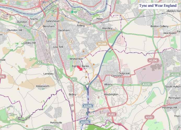
"© OpenStreetMap contributors, CC BY-SA".
Districts of Tyne and Wear

1 - Newcastle upon Tyne
2 - Gateshead
3 - South Tyneside
4 - Sunderland
5 - North Tyneside
From Wikipedia, the free encyclopedia
Tyne and Wear City and Town Maps
A
B
C
D
E
F
H
L
M
N
O
P
R
S
T
U
W
Tyne and Wear Maps — Interactive Map, Street View, Weather & News
This page provides an interactive Google map of Tyne and Wear, England with Street View, satellite and terrain views, alongside links to detailed street maps for cities, towns, villages and hamlets across the county. Tyne and Wear sits within the North East England region.
Every locality map page includes an embedded street and satellite map together with live weather where available — current conditions with hourly and 7-day outlooks powered by Open-Meteo. Local and world news feeds — including BBC News — keep pages current, and Wikipedia summaries provide additional local context.
The Search Maps button below the map opens OS Outdoor and the OS Explorer 1:25 000 sheets as base layers, with a labelled OS National Grid overlay, a distance and bearing tool, and a single-fix GPS readout giving your grid reference and latitude and longitude.
Location data is sourced from OS Open Names © Crown copyright and database rights 2024, Ordnance Survey, Open Government Licence v3.0, and verified by coordinates rather than name matching alone.