A large detailed map of County Durham, England
Explore County Durham with an interactive map featuring Street View, satellite and terrain views. Live weather, local news and location details for County Durham — plus links to detailed street maps for cities, towns, villages and hamlets across the county.
County Durham County Map
Map search is available for a limited number of queries per session to manage costs. Be specific — search precisely for best results.
| County Town | Durham |
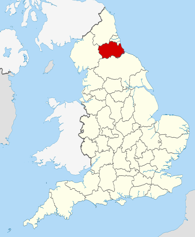
| Region | North East England |
| Country | England |
| Status | Ceremonial county |
| Area | 2,676 km² |
| Population | 533,000 |
| Latitude | 54.7116 |
| Longitude | -1.6974 |
| Cities & Towns | 487 |
| Locality Maps | Locality Maps |
About County Durham
Undulating hills, softened by centuries of pastoral stewardship, define the very soul of this northeastern shire. The River Wear, a silver ribbon, meanders through verdant valleys, its banks often cloaked in ancient woodlands that whisper tales of ages past. To the east, a rugged coastline, where dramatic cliffs plunge into the restless North Sea, offers a wild counterpoint to the gentler inland vistas. Even the dales, though less imposing than their Yorkshire neighbours, possess a quiet, stoic beauty, their contours shaped by glacial forces and the patient hand of time.
Echoes of Roman legions still resonate in the foundations of Hadrian's Wall, its shadow lengthening across the northern reaches of this historic county. The Venerable Bede, a luminary of early English scholarship, found his intellectual haven within the monastic walls of Wearmouth-Jarrow, shaping the course of religious and historical writing. Later centuries witnessed the fierce loyalties of the Prince-Bishops of Durham, their Palatinate power a bulwark against Scottish incursions, culminating in the industrial might that forged a new identity during the Victorian era.
Agriculture, a cornerstone of its rural identity, continues to sustain many communities, with sheep and cattle grazing upon the rolling fells. Yet, the county's economic narrative is inextricably linked to the coal mines that once scarred its landscape, providing the lifeblood for bustling industrial towns like Consett and Seaham. Though the pits have largely fallen silent, a spirit of manufacturing resilience persists, with modern enterprises contributing to its economic regeneration, building upon the industrious spirit of its forebears.
A forthright pragmatism, tempered by a deep-seated sense of community, characterises the people of Durham. Their traditions, often expressed in vibrant brass band performances and the enduring camaraderie forged in shared hardship, speak of a proud heritage. Figures such as the poet Tony Harrison, who captured the voice of the working class with unflinching honesty, reflect a culture that values authenticity and grit. This enduring spirit infuses the county's arts scene, its historical sites, and the everyday interactions of its inhabitants, creating a unique tapestry of life.
County Durham Maps
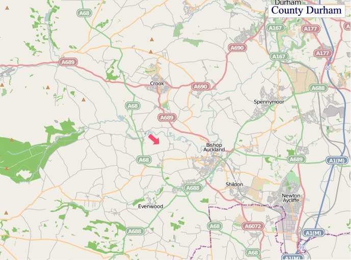
"© OpenStreetMap contributors, CC BY-SA".
Districts of County Durham
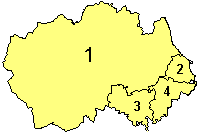
1 - Durham
2 - Hartlepool
3 - Darlington
4 - Stockton-on-Tees (north)
From Wikipedia, the free encyclopedia
County Durham City and Town Maps
A
B
C
D
E
F
G
H
I
K
L
M
N
O
P
R
S
T
U
W
County Durham Maps — Interactive Map, Street View, Weather & News
This page provides an interactive Google map of County Durham, England with Street View, satellite and terrain views, alongside links to detailed street maps for cities, towns, villages and hamlets across the county. County Durham sits within the North East England region.
Every locality map page includes an embedded street and satellite map together with live weather where available — current conditions with hourly and 7-day outlooks powered by Open-Meteo. Local and world news feeds — including BBC News — keep pages current, and Wikipedia summaries provide additional local context.
Location data is sourced from OS Open Names © Crown copyright and database rights 2024, Ordnance Survey, Open Government Licence v3.0, and verified by coordinates rather than name matching alone.