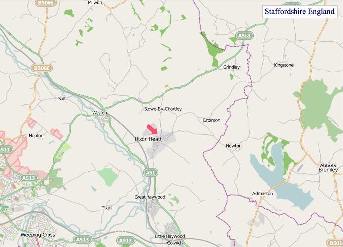
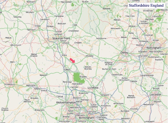
A large detailed map of Staffordshire, England
Explore Staffordshire with an interactive map featuring Street View, satellite and terrain views. Live weather, local news and location details for Staffordshire — plus links to detailed street maps for cities, towns, villages and hamlets across the county.
Staffordshire County Map
Map search is available for a limited number of queries per session to manage costs. Be specific — search precisely for best results.
| County Town | Stafford |
| Region | West Midlands |
| Country | England |
| Status | Ceremonial county |
| Area | 2,713 km² |
| Population | 1,136,000 |
| Latitude | 52.8690 |
| Longitude | -2.0606 |
| Cities & Towns | 921 |
| Locality Maps | Locality Maps |
About Staffordshire
A tapestry of rolling countryside unfolds across Staffordshire, its gentle undulations punctuated by the ancient Staffordshire Moorlands rising in the north, a wilder, heather-clad expanse that speaks of a time before plough and pasture. The River Trent, a vein of life, winds its patient course through the heart of the county, its waters reflecting the verdant fields and the occasional brooding oak. Elsewhere, the landscape softens into gentle valleys and fertile plains, a testament to the persistent industry of generations who have coaxed bounty from its soil, whilst the absence of a true coastline lends an inland, enduring character to its vistas.
Echoes of Roman legions still whisper across the land, their roads once carving pathways through this verdant territory, and the formidable earthworks of ancient hill forts stand as silent sentinels to forgotten conflicts. Later, the Saxons established their settlements, laying foundations for towns like Stafford itself, whilst the Norman Conquest left its indelible mark in stone castles and a reordered social fabric. The Industrial Revolution, however, reshaped Staffordshire with seismic force, its collieries and potteries transforming quiet villages into bustling centres of manufacture, a period of profound change that forged the modern county.
Agriculture has long been the bedrock of Staffordshire's prosperity, its dairy farms and arable lands yielding their sustenance with quiet diligence, yet it is industry that has truly defined its economic spirit. The potteries of Stoke-on-Trent, a world-renowned hub of ceramic artistry, continue to produce wares of exceptional quality, a legacy of Josiah Wedgwood and his tireless innovation. Beyond ceramics, engineering and manufacturing have flourished, with companies like JCB shaping the very earth, their robust machinery a testament to Staffordshire's enduring capacity for skilled production.
The people of Staffordshire possess a sturdy, no-nonsense character, their resilience forged in the fires of industry and the quiet perseverance of rural life, a demeanour often softened by a dry wit and a deep-seated sense of community. Traditions, from the vibrant festivals of the Black Country fringes to the enduring crafts of the potter's wheel, remain woven into the fabric of daily existence, whilst figures like the novelist Arnold Bennett captured the essence of its towns and their inhabitants with keen observation. The way of life here is one of honest labour and simple pleasures, a grounded existence that finds its beauty in the enduring strength of its people and the steadfast character of its land.
Staffordshire Maps
"© OpenStreetMap contributors, CC BY-SA".
Districts of Staffordshire
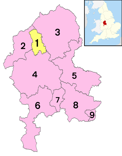
1 - City of Stoke-on-Trent
2 - Newcastle-under-Lyme
3 - Staffordshire Moorlands
4 - Stafford
5 - East Staffordshire
6 - South Staffordshire
7 - Cannock Chase
8 - Lichfield
9 - Tamworth
From Wikipedia, the free encyclopedia
Staffordshire City and Town Maps
A
B
C
D
E
F
G
H
K
L
M
N
O
P
R
S
T
U
W
Staffordshire Maps — Interactive Map, Street View, Weather & News
This page provides an interactive Google map of Staffordshire, England with Street View, satellite and terrain views, alongside links to detailed street maps for cities, towns, villages and hamlets across the county. Staffordshire sits within the West Midlands region.
Every locality map page includes an embedded street and satellite map together with live weather where available — current conditions with hourly and 7-day outlooks powered by Open-Meteo. Local and world news feeds — including BBC News — keep pages current, and Wikipedia summaries provide additional local context.
Location data is sourced from OS Open Names © Crown copyright and database rights 2024, Ordnance Survey, Open Government Licence v3.0, and verified by coordinates rather than name matching alone.