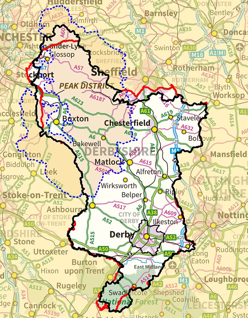
A large detailed map of Derbyshire, England
Explore Derbyshire with an interactive map featuring Street View, satellite and terrain views. Live weather, local news and location details for Derbyshire — plus links to detailed street maps for cities, towns, villages and hamlets across the county.
Derbyshire County Map
Map search is available for a limited number of queries per session to manage costs. Be specific — search precisely for best results.
| County Town | Matlock |
| Region | East Midlands |
| Country | England |
| Status | Ceremonial county |
| Area | 2,625 km² |
| Population | 1,090,000 |
| Latitude | 53.1292 |
| Longitude | -1.5660 |
| Cities & Towns | 816 |
| Locality Maps | Locality Maps |
About Derbyshire
Majestic peaks, like the proud shoulders of the Pennines, dominate Derbyshire's northern expanse, their rugged contours carved by ancient glaciers and softened by verdant slopes. The Peak District National Park, a jewel of wild beauty, offers vistas of heather-clad moorlands and dramatic limestone dales, where the Rivers Dove and Manifold weave their silvery paths through a landscape of unparalleled natural character. Downwards, the terrain gently unfurls into rolling hills and fertile plains, a tapestry of fields and woodlands bisected by the meandering Trent, its waters nourishing the very soul of this diverse county.
Ancient echoes of Roman legions still whisper across the Derbyshire soil, their encampments and roads a testament to early dominion, whilst the formidable grip of Norman lords left its mark upon castles and manors that stand as silent sentinels of centuries past. Through the turbulent ages, from the monastic wealth of the Middle Ages to the revolutionary fervour of the Industrial Revolution, Derbyshire has borne witness to pivotal moments, its towns and villages evolving from humble settlements into centres of commerce and innovation. The very fabric of England's story has been woven upon this land, its people enduring plagues, wars, and societal shifts with enduring resilience.
Ingenious spirit has long been the engine of Derbyshire's prosperity, its agricultural heartland yielding bountiful harvests whilst its industrial sinews have pulsed with the rhythm of innovation. The coal seams deep beneath the surface fuelled the furnaces of industry, birthing a legacy of ironworks and engineering prowess, whilst the swift waters of its rivers powered the mills that spun cotton and wool, earning places like Glossop and Belper reputations for textile excellence. Today, the county continues to thrive, a blend of traditional farming, advanced manufacturing, and burgeoning service industries demonstrating its enduring economic vitality.
Resilient and forthright, the people of Derbyshire possess a character forged in the crucible of hard work and a deep connection to their land, their traditions often rooted in the agricultural calendar and the communal spirit of market towns. From the legendary tales of Robin Hood, said to have roamed the Sherwood Forest fringes, to the scientific brilliance of Sir Isaac Newton, whose lineage traces back to this very soil, Derbyshire has nurtured minds of extraordinary calibre. The county's vibrant arts scene, from the Derby Theatre to the myriad of craftspeople, continues to reflect this creative vigour and a steadfast devotion to their unique way of life.
Derbyshire Maps
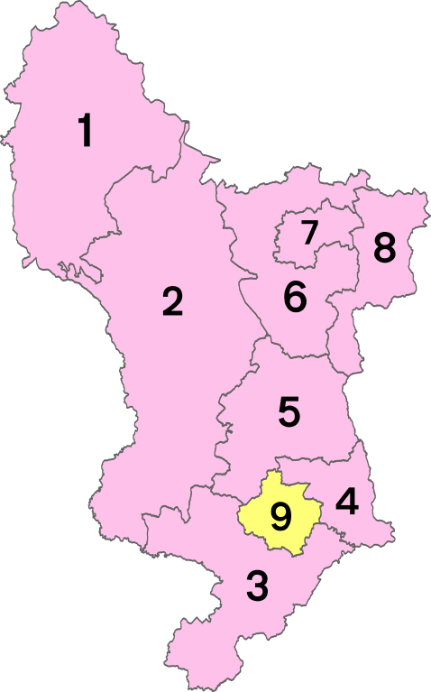
Districts of Derbyshire
1 - High Peak
2 - Derbyshire Dales
3 - South Derbyshire
4- Erewash
5 - Amber Valley
6 - North East Derbyshire
7 - Chesterfield
8 - Bolsover
9 - City of Derby
From Wikipedia, the free encyclopedia
Derbyshire City and Town Maps
A
B
C
D
E
F
G
H
I
K
L
M
N
O
P
Q
R
S
T
U
W
Y
Derbyshire Maps — Interactive Map, Street View, Weather & News
This page provides an interactive Google map of Derbyshire, England with Street View, satellite and terrain views, alongside links to detailed street maps for cities, towns, villages and hamlets across the county. Derbyshire sits within the East Midlands region.
Every locality map page includes an embedded street and satellite map together with live weather where available — current conditions with hourly and 7-day outlooks powered by Open-Meteo. Local and world news feeds — including BBC News — keep pages current, and Wikipedia summaries provide additional local context.
Location data is sourced from OS Open Names © Crown copyright and database rights 2024, Ordnance Survey, Open Government Licence v3.0, and verified by coordinates rather than name matching alone.