Sardinia (Sardegna) — Maps / Carte
Explore Sardegna, Italy, with an interactive map, and browse maps of its 8 province and 377 comuni, together with the localities and frazioni inside them.
Esplora Sardegna sulla carta interattiva e consulta le carte delle sue 8 province e dei 377 comuni.
Sardegna Map / Carta Sardegna
Map search is available for a limited number of queries per session to manage costs. Be specific — search precisely for best results.
How to Use This Sardegna, Sardinia (Sardegna) Map / Come usare questa carta
This interactive map shows the street layout and satellite imagery for Sardegna, Sardinia (Sardegna), Italy. Use the Map and Satellite buttons to switch between the street map and aerial photography. Use the + and − buttons to zoom, or hold the Control key while scrolling the mouse wheel. On a touchscreen, pinch with two fingers. Drag the map to pan anywhere in Sardinia (Sardegna) or beyond.
Street View. Drag the small figure from the bottom right of the map onto any road to drop into a 360° view at ground level. Click the arrows along the road to move along it, drag to look around, and press Escape or the back arrow to return to the map.
Click ⛶ Fullscreen to expand the map to fill the screen. To go back, press Escape, click ✕ Exit Fullscreen above the map, or on a phone tap the back button (Android) or the close icon (iOS).
SEARCH MAPS. The green 🔍 Search Maps button below the map opens a second, independent map on OpenStreetMap coverage of the whole country. Its search box finds any Italian comune, frazione, mountain or landmark by name, so you are not limited to Sardegna.
Reading the map like an IGM sheet. Click Grid to lay a labelled UTM grid over the map, quoted along the edges the way a printed IGM 1:25 000 tavoletta quotes it — at normal zoom the squares are one kilometre across, so a six-figure reference can be read by eye and distance judged straight off the map. Click Measure and tap two points for the distance between them with the grid, true and magnetic bearings, the last being the one to set on a compass.
Click 📍 My position for a single GPS fix. It marks where you are and reports it as Gauss-Boaga (the grid printed on the IGM Carta d'Italia), as ETRS89 / UTM (the grid Italy uses today), and as plain latitude and longitude, with a copy button so it can be pasted into a message. It takes one reading and stops, to save the battery. Map tiles need mobile coverage; a GPS reading does not — so the grid reference stays correct in the Apennines and the Alps, where the map itself often will not load.
Usa i pulsanti Map e Satellite per passare dalla carta stradale alla fotografia aerea, i pulsanti + e − per lo zoom, e trascina la mappa per spostarti. Trascina l'omino di Street View su una strada per la veduta a 360 gradi. Il pulsante 🔍 Search Maps apre una seconda carta su OpenStreetMap con la ricerca di qualsiasi comune, frazione o cima d'Italia, la griglia UTM quotata come su una tavoletta IGM 1:25 000, la misura di distanze e azimut (di griglia, vero e magnetico) e la lettura GPS della posizione in Gauss-Boaga, in ETRS89/UTM e in coordinate geografiche. Le tessere della mappa richiedono la rete mobile, la lettura GPS no: il riferimento resta valido anche dove la carta non si carica.
Map of Sardegna / Carta di Sardegna
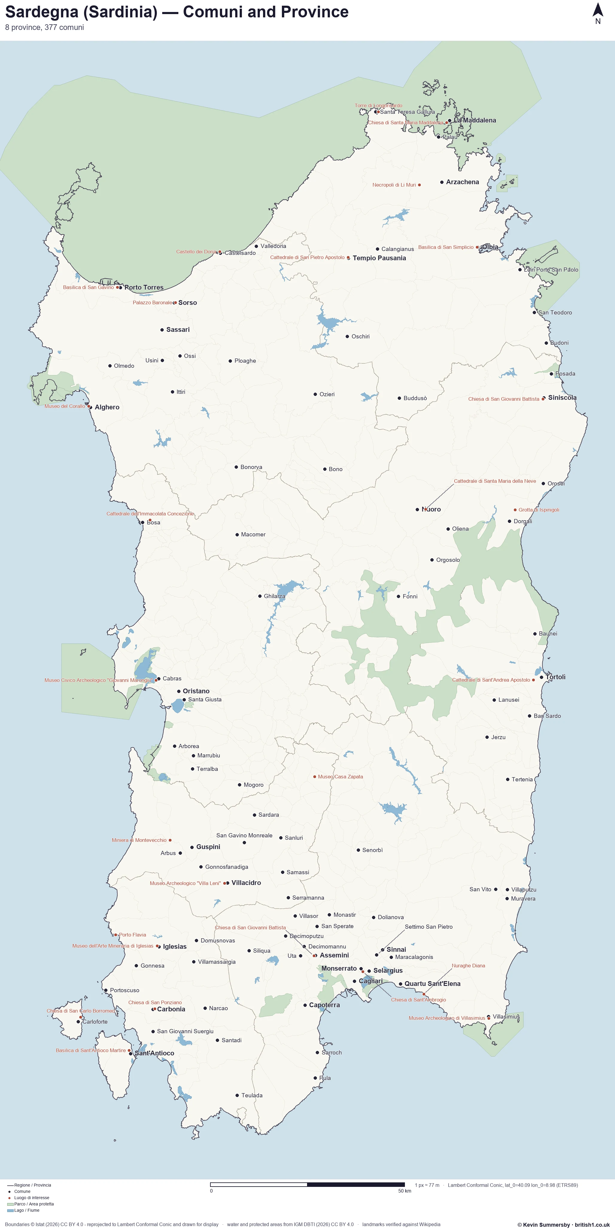
This detailed map shows the railway network, national and regional parks, and the main places of interest. Our page format reduces the display size for uniformity. Here is a link to the full-size image, which is easier to read.
Questa carta mostra la rete ferroviaria, i parchi nazionali e regionali e i principali luoghi di interesse. Ecco il collegamento all'immagine a grandezza naturale.
Google Maps; © OpenStreetMap contributors; Carta IGM © Istituto Geografico Militare (2026) CC BY 4.0; magnetic declination from NOAA NCEI (World Magnetic Model)
| Region / Regione | Sardegna |
| English name | Sardinia |
| German name | Sardinien |
| French name | Sardaigne |
| Spanish name | Cerdeña |
| Country / Paese | Italy / Italia |
| Region code | 20 |
| Province | 8 |
| Comuni | 377 |
| Place maps / Carte | 1,134 |
| Population 2021 | 1,587,413 |
About Sardegna
Sardegna is an autonomous region defined by its granite ridges and the persistent scent of macchia scrub under the heat. The landscape is marked by the presence of nuraghi towers standing on high ground. In the wider countryside, the shepherd villages of the Barbagia remain quiet, while the Gennargentu mountains dominate the horizon. The light here is sharp, bleaching the cork oak forests and reflecting off water clearer than seems reasonable. This is a frontier that has been shaped by the presence of a Roman province and the long influence of maritime republics. The unification of Italy brought significant economic changes to the island, shifting the focus of trade and industry across its distinct provinces, including Nuoro, Oristano, and Ogliastra.
Cagliari, the largest city, rests on the southern coast. Its skyline is anchored by the Bastione di Saint Remy and the Roman Amphitheatre of Cagliari. Visitors often walk to the Basilica di San Saturnino or the Basilica di Nostra Signora di Bonaria to look out toward the sea. The Castello di San Michele maintains a steady presence over the city. In the north, Sassari functions as a major center, where the Pinacoteca Nazionale di Sassari preserves local heritage. The Chiesa di San Pietro di Silki and the Palazzo Giordano reflect the urban rhythm of a place that values its own specific traditions while managing the demands of a modern economy based on textile production and marble extraction.
Quartu Sant'Elena balances urban growth with natural spaces like the Parco Naturale Regionale Molentargius - Saline. The Basilica di Sant'Elena Imperatrice serves as a focal point, while the Nuraghe Diana connects the present to a much older era. Local life often spills toward the shore at Cala Regina or visits the Chiesa di Sant'Agata. Olbia acts as a vital gateway, where the Museo Archeologico di Olbia displays artifacts from Greek and Roman times. The Basilica di San Simplicio and the Roman Aqueduct of Olbia reveal the city's role as a transit point. Nearby, the Castello di Pedres and the Nuraghe Riu Mulinu overlook the plains, witnessing the daily movement of goods and people.
Language remains a defining feature of the region. While Sardinian is spoken widely, the town of Alghero maintains its distinct Catalan heritage, a remnant of historic movements across the Mediterranean. This linguistic island creates a unique texture in the local conversation, distinguishing the west from the rest of the territory. The economy continues to rely on the land and the sea, balancing the extraction of natural resources with a growing commitment to heritage conservation. History is not a distant concept here but a series of roles played out in the provinces of Gallura Nord-Est Sardegna, Medio Campidano, Sulcis Iglesiente, and Sassari, where the resilience of the people remains the most constant element in a changing world.
Informazioni su Sardegna
La Sardegna è una regione autonoma caratterizzata da creste granitiche e dal profumo persistente della macchia mediterranea. Il paesaggio è segnato dai nuraghi che svettano su ogni altura. Nelle campagne, i villaggi dei pastori della Barbagia mantengono una quiete profonda, mentre il Gennargentu domina l'orizzonte. La luce è netta, schiarisce i boschi di sughera e si riflette su un mare di una trasparenza inusuale. Questa terra è stata una provincia romana ed è stata influenzata dalle repubbliche marinare. L'unificazione ha portato mutamenti economici rilevanti, spostando il fulcro del commercio nelle diverse province, tra cui Nuoro, Oristano e l'Ogliastra, dove la vita segue ritmi legati alla terra e al lavoro nei campi.
Cagliari, la città principale, si affaccia sulla costa meridionale. Il suo profilo è definito dal Bastione di Saint Remy e dall'Anfiteatro Romano di Cagliari. Molti visitano la Basilica di San Saturnino o la Basilica di Nostra Signora di Bonaria per osservare il mare. Il Castello di San Michele domina la città dall'alto. A nord, Sassari rappresenta un centro vitale, dove la Pinacoteca Nazionale di Sassari custodisce il patrimonio locale. La Chiesa di San Pietro di Silki e il Palazzo Giordano riflettono il ritmo urbano di un luogo che valorizza le proprie tradizioni pur gestendo le necessità di un'economia basata sulla produzione tessile e sull'estrazione del marmo, mantenendo una solida identità regionale.
Quartu Sant'Elena bilancia l'espansione urbana con aree naturali come il Parco Naturale Regionale Molentargius - Saline. La Basilica di Sant'Elena Imperatrice funge da punto di riferimento, mentre il Nuraghe Diana collega il presente a un'epoca remota. La vita locale si sposta verso il mare a Cala Regina o presso la Chiesa di Sant'Agata. Olbia funge da porta d'accesso, dove il Museo Archeologico di Olbia espone reperti di epoca greca e romana. La Basilica di San Simplicio e l'Acquedotto Romano di Olbia testimoniano il ruolo della città come punto di transito. Poco distanti, il Castello di Pedres e il Nuraghe Riu Mulinu osservano il movimento quotidiano di merci e persone lungo le rotte principali.
La lingua rimane un elemento distintivo della regione. Mentre il sardo è parlato ovunque, la città di Alghero conserva la sua eredità catalana, traccia dei movimenti storici nel Mediterraneo. Questa isola linguistica crea una consistenza unica nella conversazione locale, distinguendo l'ovest dal resto del territorio. L'economia continua a fondarsi sulla terra e sul mare, equilibrando l'estrazione di risorse naturali con l'impegno per la conservazione del patrimonio. La storia non è un concetto lontano, ma una serie di ruoli vissuti nelle province di Gallura Nord-Est Sardegna, Medio Campidano, Sulcis Iglesiente e Sassari, dove la tenacia degli abitanti rimane l'elemento più costante in un mondo in continua trasformazione.
Province and città metropolitane
| Province | Code | Comuni | Place maps |
| Cagliari | CA | 70 | 179 |
| Gallura Nord-Est Sardegna | OT | 26 | 286 |
| Medio Campidano | VS | 28 | 45 |
| Nuoro | NU | 53 | 87 |
| Ogliastra | OG | 23 | 61 |
| Oristano | OR | 87 | 134 |
| Sassari | SS | 66 | 165 |
| Sulcis Iglesiente | CI | 24 | 177 |
Largest comuni / Comuni principali
About This Sardegna Map Page / Informazioni su questa pagina
Explore Sardegna, Italy, Italy, with a Google street and satellite map — switch between the two with the buttons on the map. Street View gives a ground-level view along the roads. Coordinates: 40.0055, 8.974. Place names, the comune and provincia hierarchy and the population come from Istat: the administrative boundaries of 1 January 2026 and the 2021 census of inhabited localities. Local and world news feeds keep the page current, and the bilingual description is written from the data this site holds rather than copied from elsewhere. This hub links to each of the 8 province of the region and to 1,134 place maps.
Search Maps opens a second, independent map. It searches OpenStreetMap for any Italian comune, frazione, mountain or landmark by name; overlays a labelled UTM grid quoted the way a printed IGM 1:25 000 tavoletta quotes it; measures distance with grid, true and magnetic bearings between any two points; and takes a single GPS fix reporting your position as a Gauss-Boaga reference, as ETRS89 / UTM, and as latitude and longitude. Map tiles need mobile coverage, but a GPS position does not, so the grid reference stays correct where the map cannot load.
There is no topographic layer on these pages. The Istituto Geografico Militare serves its Carta d'Italia only inside the EU, so an Italian equivalent of the 1:25 000 walking sheet cannot be shown here — the UTM grid over OpenStreetMap is what stands in its place.
Carta interattiva di Sardegna, Italy, con veduta stradale e satellitare. Toponimi, gerarchia comune/provincia e popolazione provengono dall'Istat: confini amministrativi al 1° gennaio 2026 e censimento 2021 delle località abitate. Il pulsante Search Maps apre una seconda carta su OpenStreetMap con ricerca per nome, griglia UTM quotata come su una tavoletta IGM 1:25 000, misura di distanze e azimut, e lettura GPS in Gauss-Boaga, ETRS89/UTM e coordinate geografiche. Non è presente un livello topografico: l'IGM distribuisce la Carta d'Italia solo all'interno dell'Unione Europea.
| Page built | October 2026 |
| Place data | Istat confini amministrativi and basi territoriali (località abitate, censimento 2021) © Istat (2026) CC BY 4.0. Data modified / Dati modificati: coordinates converted from UTM zone 32N to WGS84; page addresses use unaccented names; officially bilingual names are split into their Italian and minority-language forms. |
| Map layers | Google Maps; © OpenStreetMap contributors; Carta IGM © Istituto Geografico Militare (2026) CC BY 4.0; magnetic declination from NOAA NCEI (World Magnetic Model) |