A large detailed map of Merseyside, England
Explore Merseyside with an interactive map featuring Street View, satellite and terrain views. Live weather, local news and location details for Merseyside — plus links to detailed street maps for cities, towns, villages and hamlets across the county.
Merseyside County Map
Map search is available for a limited number of queries per session to manage costs. Be specific — search precisely for best results.
| County Town | Liverpool |
| Region | North West England |
| Country | England |
| Status | Metropolitan county |
| Area | 645 km² |
| Population | 1,425,000 |
| Latitude | 53.4327 |
| Longitude | -2.9081 |
| Cities & Towns | 257 |
| Locality Maps | Locality Maps |
About Merseyside
Mersey waters carve a serpentine path through the low-slung plains, where the Wirral peninsula reaches out like a weathered hand toward the grey Irish Sea. Sand dunes shift restlessly along the Sefton coast, offering a stark, wild beauty against the industrial silhouettes that haunt the horizon. Distant ridges of the Pennines loom as a faint, jagged memory, yet the immediate earth remains a land of reclaimed marsh and tidal estuary. Nature here is a creature of salt-spray and squalls, tempered by the persistent bite of winds that whip across the exposed mudflats. Every inlet tells a tale of the tide, where the river meets the surge in a perpetual, churning dance of silt and foam.
Vikings once steered their dragon-prowed vessels into these sheltered channels, leaving echoes of their fierce settlement upon the local tongue and topography. Roman legions may have trod these marshy peripheries, but the true crucible of the region ignited when the port of Liverpool rose to command the Atlantic trade. Centuries of mercantile expansion transformed quiet hamlets into a sprawling labyrinth of docks, forging a gateway that linked the British Empire to the far-flung corners of the globe. World wars brought both ruin and resilience, scarring the waterfront with fire yet failing to dampen the indomitable spirit of those who laboured amidst the brick and stone. History remains etched into the very fabric of the cathedrals and warehouses that stand as monuments to a past both prosperous and profound.
Industry defines the heartbeat of this landscape, where the rhythmic clamour of the shipyards once dictated the tempo of daily existence. Iron, coal, and cotton flowed through the veins of the region, driving a manufacturing engine that powered the ambitions of a nation. Great enterprises, from the sprawling docks of Birkenhead to the automotive assembly lines of Halewood, have long provided the sinew for the local economy. Though the smoke of the heavy furnaces has largely cleared, the legacy of innovation persists in modern logistics and the burgeoning maritime tech of the twenty-first century. Labour remains a sacred virtue here, rooted in the grit of those who built the great vessels that conquered the deep.
People possess a wit as sharp as the sea air, tempered by a communal warmth that defies the cold indifference of a changing world. Artists, poets, and musicians have long drawn inspiration from the melancholic charm of the docks, turning the local vernacular into a lyrical force that resonates across the continents. Traditions are upheld with a stubborn pride, whether expressed through the fervent devotion to the football terraces or the vibrant, eclectic gatherings of the city streets. Figures like Lennon and McCartney emerged from this crucible of grey skies and neon nights, forever altering the cultural tapestry of humanity. Life here is a conversation between the past and the present, spoken by a populace whose spirit remains as resilient and vast as the river that sustains them.
Merseyside Maps
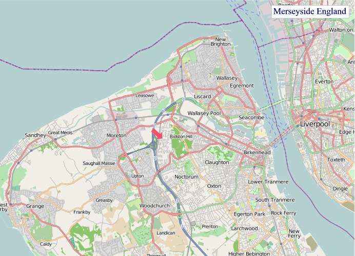
"© OpenStreetMap contributors, CC BY-SA".
Districts of Merseyside
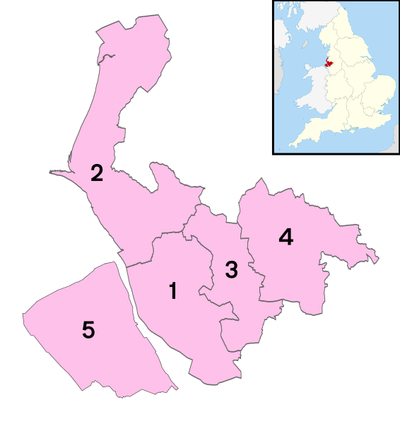
1 - City of Liverpool
2 - Sefton
3 - Knowsley
4 - St Helens
5 - Wirral
From Wikipedia, the free encyclopedia
Merseyside City and Town Maps
A
B
C
D
E
F
G
H
I
K
L
M
N
O
P
R
S
T
U
W
Merseyside Maps — Interactive Map, Street View, Weather & News
This page provides an interactive Google map of Merseyside, England with Street View, satellite and terrain views, alongside links to detailed street maps for cities, towns, villages and hamlets across the county. Merseyside sits within the North West England region.
Every locality map page includes an embedded street and satellite map together with live weather where available — current conditions with hourly and 7-day outlooks powered by Open-Meteo. Local and world news feeds — including BBC News — keep pages current, and Wikipedia summaries provide additional local context.
The Search Maps button below the map opens OS Outdoor and the OS Explorer 1:25 000 sheets as base layers, with a labelled OS National Grid overlay, a distance and bearing tool, and a single-fix GPS readout giving your grid reference and latitude and longitude.
Location data is sourced from OS Open Names © Crown copyright and database rights 2024, Ordnance Survey, Open Government Licence v3.0, and verified by coordinates rather than name matching alone.