A large detailed map of North Yorkshire, England
Explore North Yorkshire with an interactive map featuring Street View, satellite and terrain views. Live weather, local news and location details for North Yorkshire — plus links to detailed street maps for cities, towns, villages and hamlets across the county.
North Yorkshire County Map
Map search is available for a limited number of queries per session to manage costs. Be specific — search precisely for best results.
| County Town | Northallerton |
| Region | Yorkshire and the Humber |
| Country | England |
| Status | Ceremonial county |
| Area | 8,654 km² |
| Population | 616,000 |
| Latitude | 54.1607 |
| Longitude | -1.3849 |
| Cities & Towns | 1,207 |
| Locality Maps | Locality Maps |
About North Yorkshire
Vastness unfolds across North Yorkshire, a tapestry woven from rolling heather-clad moors, their purple hues deepening with the lowering sun, and the stark, dramatic embrace of the North York Moors National Park. The White Horse of Kilburn gallops across the hillside, a testament to the enduring spirit of the land, whilst the sinuous curves of the River Ouse and the Swale carve their paths through verdant dales, their waters reflecting the ever-changing sky. Along its eastern flank, the rugged coastline, battered by the relentless North Sea, offers breathtaking vistas of sea stacks and sandy bays, a wild and untamed beauty that speaks of ancient geological forces.
Echoes of ages past resonate within this ancient landscape, from the Roman roads that still faintly scar the earth near Malton to the formidable stone ramparts of Scarborough Castle, which has witnessed sieges and triumphs through centuries of English history. Viking longships once beached near Whitby, leaving a lasting imprint on its character, whilst the medieval grandeur of Fountains Abbey, now a majestic ruin, whispers tales of monastic life and Reformation upheaval. Later, the industrial revolution brought its own chapter, shaping towns like Middlesbrough and transforming coastal ports into centres of commerce and innovation.
Agriculture remains the lifeblood of much of North Yorkshire, its fertile valleys yielding bountiful harvests and supporting a venerable tradition of sheep farming on the higher ground. Beyond the fields, a resilient industrial heritage persists, particularly in the Tees Valley, where steelmaking and chemical industries, though transformed, still contribute significantly to the regional economy. Manufacturing enterprises, from artisanal food producers to specialist engineering firms, also play a vital role, demonstrating a quiet but determined pursuit of quality and craftsmanship.
A sturdy independence and a warm, pragmatic spirit define the people of North Yorkshire, their character forged by the very landscape they inhabit. Traditions endure in village fêtes and agricultural shows, where the rhythm of rural life continues with unwavering dedication. Literary giants like the Brontë sisters, though their most famous works are set further afield, drew inspiration from the wild moorlands, whilst contemporary artists and craftspeople continue to find voice in this inspiring corner of England, perpetuating a way of life that values community and connection.
North Yorkshire Maps
"© OpenStreetMap contributors, CC BY-SA".
Districts of North Yorkshire
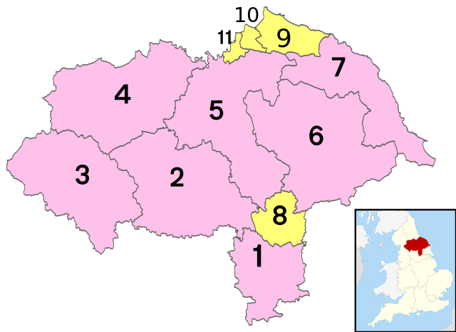
County districts:
1 - Selby
2 - Harrogate
3 - Craven
4 - Richmondshire
5 - Hambleton
6 - Ryedale
7 - Scarborough
Unitary districts:
8 - City of York
9 - Redcar and Cleveland
10 - Middlesbrough
11 - Stockton-on-Tees (south)
From Wikipedia, the free encyclopedia
North Yorkshire City and Town Maps
A
B
C
D
E
F
G
H
I
J
K
L
M
N
O
P
R
S
T
U
W
North Yorkshire Maps — Interactive Map, Street View, Weather & News
This page provides an interactive Google map of North Yorkshire, England with Street View, satellite and terrain views, alongside links to detailed street maps for cities, towns, villages and hamlets across the county. North Yorkshire sits within the Yorkshire and the Humber region.
Every locality map page includes an embedded street and satellite map together with live weather where available — current conditions with hourly and 7-day outlooks powered by Open-Meteo. Local and world news feeds — including BBC News — keep pages current, and Wikipedia summaries provide additional local context.
Location data is sourced from OS Open Names © Crown copyright and database rights 2024, Ordnance Survey, Open Government Licence v3.0, and verified by coordinates rather than name matching alone.