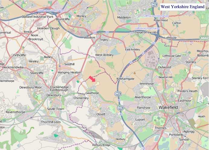
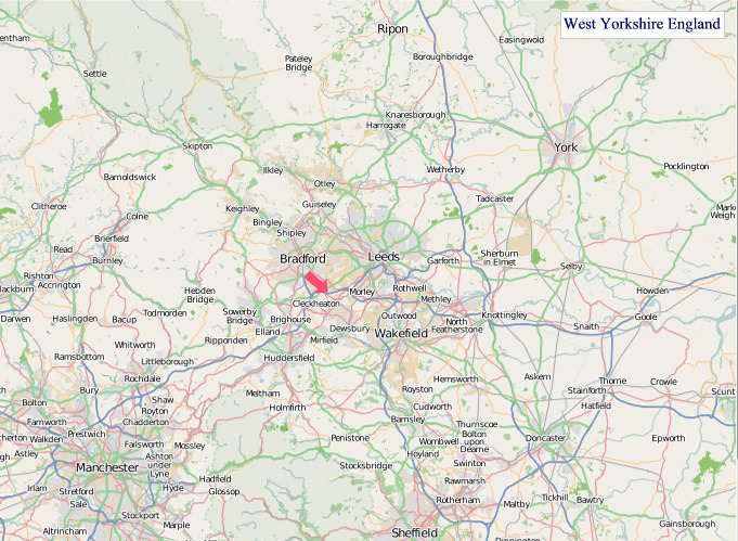
A large detailed map of West Yorkshire, England
Explore West Yorkshire with an interactive map featuring Street View, satellite and terrain views. Live weather, local news and location details for West Yorkshire — plus links to detailed street maps for cities, towns, villages and hamlets across the county.
West Yorkshire County Map
Map search is available for a limited number of queries per session to manage costs. Be specific — search precisely for best results.
| County Town | Wakefield |
| Region | Yorkshire and the Humber |
| Country | England |
| Status | Metropolitan county |
| Area | 2,029 km² |
| Population | 2,320,000 |
| Latitude | 53.7380 |
| Longitude | -1.6855 |
| Cities & Towns | 1,146 |
| Locality Maps | Locality Maps |
About West Yorkshire
Verdant valleys, carved by the patient hand of time, cradle West Yorkshire’s undulating terrain, where the Pennines rise with stoic grace, their heather-clad shoulders often veiled in mist. The Aire and Calder rivers, ancient arteries of commerce and life, weave through the landscape, their waters reflecting the brooding skies and the resilient spirit of the region. Though far from the sea, a wild, elemental beauty pervades, conjuring images of rugged moorland and the persistent whisper of the wind across the open fells, a stark yet captivating panorama. This is a land of dramatic contrasts, where gentle slopes give way to formidable heights, a testament to nature's enduring artistry.
Echoes of Roman legions and Viking raids resonate through West Yorkshire's storied past, a tapestry woven with threads of conquest and settlement. From the ancient earthworks of the Brigantes to the burgeoning wool towns of the Middle Ages, the land has witnessed profound transformations. Wakefield's pivotal role in the Wars of the Roses, the Industrial Revolution's fiery birth in Leeds and Bradford, and the ongoing legacy of its textile heritage all speak to a history of resilience and innovation. These layers of time, from medieval abbeys to Victorian mills, imbue the very soil with a palpable sense of human endeavour.
Prosperity in West Yorkshire has long been forged in the crucible of industry, its fortunes shaped by the raw materials drawn from its soil and the ingenuity of its people. Agriculture, though still present, has yielded to the dominance of manufacturing, particularly in textiles, engineering, and printing, with Leeds and Bradford becoming titans of production. The mills that once dominated the skylines, monuments to a bygone era, now often stand repurposed, a testament to the region's adaptability. Modern enterprises continue to thrive, building upon this formidable industrial foundation, a continuing narrative of economic vitality.
Resolute and forthright, the people of West Yorkshire possess a character as robust as their homeland, their traditions deeply rooted in hard work and community spirit. A dry wit and a ready humour are hallmarks of their disposition, often expressed through the vibrant local dialects that still colour conversation. Figures like the Brontë sisters, drawing inspiration from the wild moors, and the artistic dynamism of the Leeds art scene, reflect a profound connection to their surroundings. The way of life here, though modernised, retains an authenticity, a groundedness that speaks of generations who have shaped and been shaped by this remarkable corner of England.
West Yorkshire Maps
"© OpenStreetMap contributors, CC BY-SA".
Districts of West Yorkshire
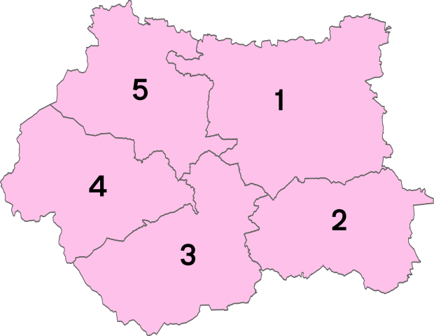
1 - City of Leeds
2 - City of Wakefield
3 - Kirklees
4 - Calderdale
5 - City of Bradford
From Wikipedia, the free encyclopedia
West Yorkshire City and Town Maps
A
B
C
D
E
F
G
H
I
K
L
M
N
O
P
Q
R
S
T
U
W
West Yorkshire Maps — Interactive Map, Street View, Weather & News
This page provides an interactive Google map of West Yorkshire, England with Street View, satellite and terrain views, alongside links to detailed street maps for cities, towns, villages and hamlets across the county. West Yorkshire sits within the Yorkshire and the Humber region.
Every locality map page includes an embedded street and satellite map together with live weather where available — current conditions with hourly and 7-day outlooks powered by Open-Meteo. Local and world news feeds — including BBC News — keep pages current, and Wikipedia summaries provide additional local context.
Location data is sourced from OS Open Names © Crown copyright and database rights 2024, Ordnance Survey, Open Government Licence v3.0, and verified by coordinates rather than name matching alone.