A large detailed map of Somerset, England
Explore Somerset with an interactive map featuring Street View, satellite and terrain views. Live weather, local news and location details for Somerset — plus links to detailed street maps for cities, towns, villages and hamlets across the county.
Somerset County Map
Map search is available for a limited number of queries per session to manage costs. Be specific — search precisely for best results.
| County Town | Taunton |
| Region | South West England |
| Country | England |
| Status | Ceremonial county |
| Area | 4,171 km² |
| Population | 970,000 |
| Latitude | 51.0789 |
| Longitude | -2.8733 |
| Cities & Towns | 1,165 |
| Locality Maps | Locality Maps |
About Somerset
A tapestry of gentle undulations and dramatic ascents, Somerset unfolds its natural character with a captivating grace. The Mendip Hills, like ancient sentinels, guard the northern reaches, their limestone scars whispering tales of geological epochs, whilst further south the Quantocks offer a wilder, more rugged beauty. The River Parrett, a silver ribbon, meanders through fertile plains, feeding the lifeblood of the county, and its estuary opens to the Bristol Channel, a wild and elemental coast where the sea's breath is ever-present. This land, a verdant expanse, invites contemplation and discovery, a place where the sky seems to hold a deeper hue.
Echoes of antiquity resonate through Somerset's storied past, from Roman villas that once graced its soil to the Saxon kingdoms that shaped its early identity. Glastonbury Tor, a mystical beacon, stands as a testament to centuries of pilgrimage and legend, whilst Alfred the Great's defiance against the Danes at Athelney marks a pivotal moment in English history. The county bore witness to the Dissolution of the Monasteries, the turbulence of the English Civil War, and the industrial stirrings of the 18th and 19th centuries, each era leaving its indelible mark upon the land and its people.
Agriculture forms the backbone of Somerset's enduring economy, its fertile lands yielding bountiful harvests of cider apples, dairy produce, and grain, a tradition upheld with quiet pride. Beyond the fields, a resilient spirit of enterprise thrives, with the county being a significant hub for manufacturing, particularly in aerospace and defence sectors in areas like Yeovil. Traditional crafts, such as fine pottery and cheese-making, continue to flourish, demonstrating a commitment to quality and heritage that underpins the region's prosperity.
A welcoming spirit and a deep connection to the land define the character of Somerset's inhabitants, a people whose traditions are woven into the fabric of rural life. The county's villages and market towns, from the honey-hued stone of Wells to the bustling streets of Taunton, retain a distinct charm and a strong sense of community. Here, folk music often fills the air, and local festivals celebrate the turning of the seasons, whilst figures like the poet Samuel Taylor Coleridge found inspiration in its pastoral landscapes, contributing to an artistic legacy that continues to enrich the county's vibrant tapestry.
Somerset Maps
"© OpenStreetMap contributors, CC BY-SA".
Districts of Somerset
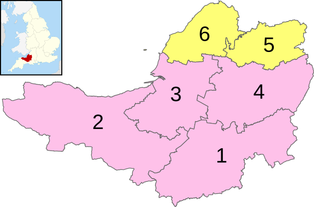
1 - South Somerset
2 - Somerset West and Taunton
3 - Sedgemoor
4 - Mendip
5 - Bath and North East Somerset (Unitary)
6 - North Somerset (Unitary)
From Wikipedia, the free encyclopedia
Somerset City and Town Maps
A
B
C
D
E
F
G
H
I
K
L
M
N
O
P
R
S
T
U
V
W
Y
Somerset Maps — Interactive Map, Street View, Weather & News
This page provides an interactive Google map of Somerset, England with Street View, satellite and terrain views, alongside links to detailed street maps for cities, towns, villages and hamlets across the county. Somerset sits within the South West England region.
Every locality map page includes an embedded street and satellite map together with live weather where available — current conditions with hourly and 7-day outlooks powered by Open-Meteo. Local and world news feeds — including BBC News — keep pages current, and Wikipedia summaries provide additional local context.
Location data is sourced from OS Open Names © Crown copyright and database rights 2024, Ordnance Survey, Open Government Licence v3.0, and verified by coordinates rather than name matching alone.