A large detailed map of West Sussex, England
Explore West Sussex with an interactive map featuring Street View, satellite and terrain views. Live weather, local news and location details for West Sussex — plus links to detailed street maps for cities, towns, villages and hamlets across the county.
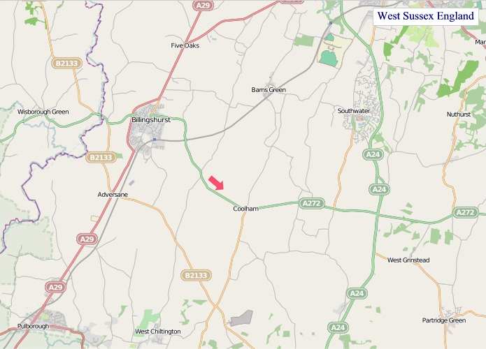
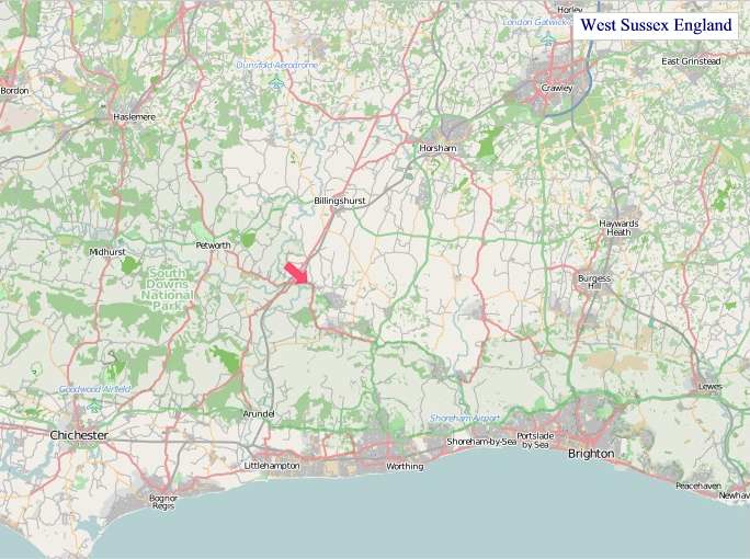
West Sussex County Map
Map search is available for a limited number of queries per session to manage costs. Be specific — search precisely for best results.
| County Town | Chichester |
| Region | South East England |
| Country | England |
| Status | Ceremonial county |
| Area | 1,991 km² |
| Population | 884,000 |
| Latitude | 50.9444 |
| Longitude | -0.5100 |
| Cities & Towns | 487 |
| Locality Maps | Locality Maps |
About West Sussex
Gentle undulations define the land, a tapestry woven with rolling chalk downs, their ancient spines catching the sun, and the verdant embrace of the South Downs National Park. The Arun and Adur rivers, silver ribbons, carve their paths towards the coast, where the pebbled shores of Shoreham and Littlehampton meet the restless English Channel. Glimpses of heathland, tinged with purple heather in late summer, offer a wilder counterpoint to the cultivated fields, a landscape that breathes with a quiet, enduring beauty.
Echoes of Roman legions linger in the very soil, remnants of villas and roads a testament to their early dominion, while Saxon settlements, like Chichester's historic core, speak of a more enduring English heritage. The Normans left their mark with formidable castles, and the medieval period saw market towns flourish, their ancient buildings bearing witness to centuries of trade and community. Later, during the Second World War, the county served as a vital defence line, its coastal towns and airfields playing a crucial role in the nation's survival.
Agriculture remains the lifeblood of many communities, with fertile soils yielding bountiful crops of grain and vegetables, and sheep grazing the chalky uplands. Modern industry has found its footing too, particularly around Crawley and Gatwick, with aerospace and logistics forming significant sectors, while the historic fishing fleets still ply their trade from harbours like Littlehampton. The county also supports a vibrant array of small businesses and artisanal producers, contributing to a diverse and resilient economy.
The people of West Sussex possess a grounded character, a blend of the rural stoicism of the farmer and the bustling energy of those who work the county's transport hubs. Local traditions persist, from the summer fêtes in charming villages to the lively farmers' markets in Horsham, offering a taste of authentic community life. This is a place where the arts find expression in galleries and theatres, attracting a creative spirit, and where the pace of life allows for a deep appreciation of the surrounding natural and historical splendours.
West Sussex Maps
"© OpenStreetMap contributors, CC BY-SA".
Districts of West Sussex
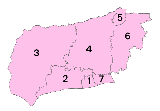
1 - Worthing
2 - Arun
3 - Chichester
4 - Horsham
5 - Crawley
6 - Mid Sussex
7 - Adur
From Wikipedia, the free encyclopedia
West Sussex City and Town Maps
A
B
C
D
E
F
G
H
I
K
L
M
N
O
P
R
S
T
U
W
Y
West Sussex Maps — Interactive Map, Street View, Weather & News
This page provides an interactive Google map of West Sussex, England with Street View, satellite and terrain views, alongside links to detailed street maps for cities, towns, villages and hamlets across the county. West Sussex sits within the South East England region.
Every locality map page includes an embedded street and satellite map together with live weather where available — current conditions with hourly and 7-day outlooks powered by Open-Meteo. Local and world news feeds — including BBC News — keep pages current, and Wikipedia summaries provide additional local context.
Location data is sourced from OS Open Names © Crown copyright and database rights 2024, Ordnance Survey, Open Government Licence v3.0, and verified by coordinates rather than name matching alone.