Maps of Bedfordshire County England
Home > Maps of England > Bedfordshire County Maps
Welcome to our Bedfordshire County map page. The map of Bedfordshire England that is located below is provided by Google Maps. You can "grab" the electronic map and move it around to re-center the map. You can change between standard map view and satellite map view by clicking the small square on the bottom left-hand corner of the map. Satellite map view utilises orbiting satellite and / or aerial high-resolution photography to display images of the map location to street level detail (really quite amazing). Standard map view shows a traditional street map (also known as a road map). You can use the zoom buttons on the bottom right-hand side of the map to zoom in or out to street level detail. We have digital online maps for most towns and cities on the Maps of England page. We also have a good collection of old school printable maps on the Maps of England page.
A map of Bedfordshire County, England
I hope you like the Bedfordshire County, England+ 2 End United Kingdom Maps
Bedfordshire County Maps
Ampthill |
Arlesey |
Aspley Guise |
Barton-le-Clay |
Bedford |
Beeston |
Biddenham |
Biggleswade |
Bletsoe
Blunham |
Caddington |
Cardington |
Clapham |
Clifton |
Clophill |
Cranfield |
Dunstable |
Eaton Bray |
Elstow
Eversholt |
Felmersham |
Flitton |
Flitwick |
Gravenhurst |
Greenfield |
Harlington |
Harrold |
Haynes |
Henlow
Hockliffe |
Houghton Regis |
Kempston |
Keysoe |
Knotting and Souldrop |
Langford |
Leagrave |
Leighton Buzzard
Lidlington |
Luton |
Marston Moretaine |
Maulden |
Meppershall |
Millbrook |
Milton Ernest |
Northill |
Oakley
Odell |
Old Warden |
Pavenham |
Pertenhall |
Potton |
Pulloxhill |
Radwell |
Ravensden |
Renhold |
Ridgmont
Riseley |
Sandy |
Sharnbrook |
Shefford |
Shillington |
Silsoe |
Souldrop |
Stagsden |
Stewartby |
Stotfold
Studham |
Sutton |
Thurleigh |
Toddington |
Totternhoe |
Turvey |
Upper Dean |
Whipsnade |
Willington |
Wilstead
Woburn |
Wootton |
Yielden
Bedfordshire County Map
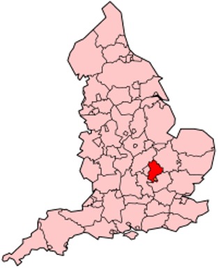
Bedfordshire is a county in England that forms part of the East of England region.
Its county town is Bedford. It borders Cambridgeshire, Northamptonshire, Buckinghamshire (and the Borough of Milton Keynes) and Hertfordshire.
The highest elevation point is 243 metres (797 ft) on Dunstable Downs in the Chilterns.
The county motto is "Constant Be", which is taken from the hymn To Be A Pilgrim by John Bunyan.
As part of a 2002 marketing campaign, the plant conservation charity Plantlife chose the Bee Orchid as the county flower.
The traditional nickname for people from Bedfordshire is "Bedfordshire Bulldogs" or "Clangers", this last deriving from a local dish comprising a suet crust dumpling filled with meat or jam or both.
Districts of Bedfordshire County
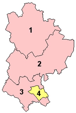
1. Bedford
2. Mid Bedfordshire
3. South Bedfordshire
4. Luton
From Wikipedia, the free encyclopedia
Music


