Enter your search query in the box below.
A large detailed map of Hampshire, England
Explore Hampshire with an interactive map featuring address search, nearby places, live weather, Street View and detailed location information. View satellite, terrain and road map layers across Hampshire, England. Designed for fast access during travel planning and emergencies, including storms, flooding and severe weather.
Hampshire County Map
Loading map…
Map search is available for a limited number of queries per session to manage costs. Be specific — search precisely for best results.
Hampshire
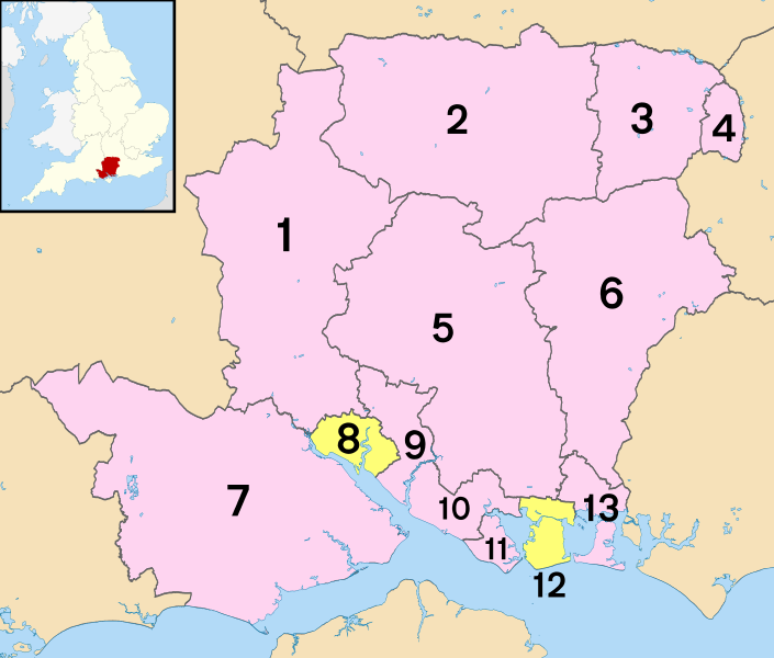
Districts of Hampshire
1 - Test Valley
2 - Basingstoke and Deane
3 - Hart
4 - Rushmoor
5 - Winchester
6 - East Hampshire
7 - New Forest
8 - Southampton (unitary)
9 - Eastleigh
10 - Fareham
11 - Gosport
12 - Portsmouth (unitary)
13 - Havant
Hampshire City and Town Maps
A
Abbots Worthy | Abbotstone | Abbotswood | Abbotts Ann | Abbotts Barton | Abshot | Adbury | Aldermoor | Aldershot | Allbrook | Allum Green | Alton | Alverstoke | Ampfield | Amport | Anchorage Park | Andover | Andover Down | Andwell | Anmore | Anna Valley | Anstey | Anthill Common | Applemore | Appleshaw | Arford | Ashe | Ashe Warren | Ashfield | Ashford | Ashford Hill | Ashlett | Ashley | Ashley | Ashley | Ashmansworth | Ashton | Ashurst | Ashurst Bridge | Avington | Avon | Awbridge | Axford | Axmansford
B
Badger Farm | Baffins | Bagmore | Bagnum | Bailey Green | Bailey's Hard | Ball Hill | Balmerlawn | Banister's Park | Bank | Bar End | Barford | Bartley | Barton Stacey | Barton on Sea | Bashley | Basingstoke | Bassett | Battramsley | Baughurst | Baughurst Common | Baybridge | Beaulieu | Beauworth | Beckley | Bedenham | Bedford Place | Bedhampton | Beech | Beech Hill | Belbins | Bellevue | Bentley | Bentworth | Bevois Mount | Bevois Town | Bevois Valley | Bickton | Bighton | Binley | Binsted | Bishop's Green | Bishop's Sutton | Bishop's Waltham | Bishopstoke | Bisterne | Bisterne Close | Bitterne | Bitterne Manor | Bitterne Park | Black Dam | Blackfield | Blackhill | Blackmoor | Blacknest | Blackwater | Blashford | Blendworth | Blissford | Blounce | Boarhunt | Boldre | Boorley Green | Bordon | Bossington | Botley | Bowling Alley | Boyatt Wood | Bradley | Braishfield | Brambridge | Bramdean | Bramley | Bramley Corner | Bramley Green | Bramshaw | Bramshill | Bramshott | Bramshott Chase | Bransbury | Bransgore | Breamore | Brickhill | Bridgemary | Brighton Hill | Broad Layings | Broad Oak | Broadgate | Broadmere | Brockbridge | Brockenhurst | Brockhampton | Brockhurst | Brokenford | Brook | Brook | Brook Hill | Broughton | Brown Candover | Brown Heath | Browninghill Green | Buckland | Buckland | Bucklers Hard | Bucks Horn Oak | Buckskin | Buddle | Bulbery | Bull Hill | Burghclere | Burghclere Common | Buriton | Burkham | Burley | Burley Street | Burridge | Bursledon | Butlocks Heath | Buttsash
C
Cadnam | Calmore | Calshot | Camdentown | Canada | Canada Common | Carter's Clay | Catherington | Catisfield | Causeway | Chalton | Chandler's Ford | Chapel | Charlton | Charlwood | Charter Alley | Chawton | Cheriton | Chidden | Chilbolton | Chilbolton Down | Chilcomb | Chilton Candover | Chilworth | Chilworth Old Village | Chineham | Church Crookham | Church End | Clanfield | Clanville | Clayhall | Cliddesden | Cocksford Down | Colbury | Colden Common | Cole Henley | Colemore | Compton | Compton | Conford | Coombe | Copnor | Copythorne | Corhampton | Cosham | Cottonworth | Cove | Cowplain | Coxford | Crampmoor | Crawley | Criddlestyle | Critchell's Green | Crockerhill | Crondall | Crookham Village | Crookhorn | Crosshouse | Crow | Crowdhill | Crux Easton | Cuckoo Bushes | Cuckoo's Corner | Cufaude | Cupernham | Curbridge | Curdridge | Custards
D
Damerham | Danebury | Daneshill | Deadwater | Dean | Dean | Deane | Denmead | Denvilles | Dibden | Dibden Purlieu | Dilton | Dipley | Dogmersfield | Dora's Green | Dowd's Farm | Downend | Downton | Drayton | Drayton | Droxford | Duck Street | Dummer | Dunbridge | Dundridge | Dunley | Durley | Durley Street | Durns Town | Durrants
E
Earlstone Common | East Anton | East Boldre | East Cholderton | East Dean | East End | East End | East Hill | East Liss | East Martin | East Meon | East Oakley | East Stratton | East Tisted | East Tytherley | East Wellow | East Woodhay | East Worldham | Eastleigh | Eastney | Eastoke | Easton | Eastrop | Ecchinswell | Egbury | Egypt | Eling | Ellingham | Ellisfield | Elson | Elvetham | Elvetham Heath | Emery Down | Empshott | Empshott Green | Emsworth | Enham Alamein | Eversley Centre | Eversley Cross | Everton | Ewshot | Exbury | Exton
F
Faccombe | Fair Cross | Fair Oak | Fair Oak | Fairdown | Fareham | Farleigh Wallop | Farlington | Farnborough | Farnborough Park | Farnborough Street | Fawley | Filmore Hill | Finchdean | Fisher's Pond | Fleet | Fleet | Fleetend | Fleetlands | Fordingbridge | Forest Corner | Forton | Forton | Foulford | Four Marks | Fox Lane | Foxcotte | Foxhall | Foxhills | Fratton | Freefolk | Freemantle | Frenchmoor | Fritham | Frithend | Frogham | Frogmore | Frogmore | Frost Hill | Frostlane | Froxfield Green | Fryern Hill | Fulflood | Fullerton | Funtley | Furze Hill | Furzedown | Furzeley Corner | Furzey Lodge | Furzley | Fyfield
G
Gable Head | Gilbert Street | Gilbury Hard | Glebe | Godshill | Godshill Wood | Godwinscroft | Golden Pot | Goodworth Clatford | Goose Green | Goose Hill | Gore End | Gosport | Grateley | Grayshott | Great Shoddesden | Greatham | Greywell | Gritnam | Gundleton | Gunville
H
Hale | Halterworth | Hamble-le-Rice | Hambledon | Hammer Bottom | Hammond's Green | Hampton Park | Hangersley | Hannington | Harbridge | Hardley | Harefield | Harefield | Harestock | Hartfordbridge | Hartley Wespall | Hartley Wintney | Hatch | Hatch Warren | Hatchet Green | Hatherden | Hattingley | Havant | Hawkley | Hawley | Hawthorn | Hazeley | Hazeley Bottom | Headbourne Worthy | Headley | Headley | Headley Down | Heath End | Heath End | Heathfield | Heathfield | Heckfield | Hedge End | Hensting | Herriard | High Cross | Highbridge | Highbury | Highclere | Highcliffe | Highfield | Hightown | Hightown | Highways | Hill | Hill Brow | Hill Grove | Hill Head | Hill Park | Hill Top | Hillhead | Hillpound | Hillstreet | Hillyfields | Hilsea | Hiltingbury | Hinton | Hinton Ampner | Hipley | Hocombe | Hoe | Hoe Gate | Holbury | Hollington | Hollington Cross | Hollywater | Holt | Holt End | Holt Pound | Holybourne | Honeywood Mews | Hook | Hook | Hook Park Estate | Hordle | Horndean | Horris Hill | Horsebridge | Horseport | Horton Heath | Houghton | Hound | Hound Green | Houndmills | Hounsdown | Hundred Acres | Hungerford | Hunton | Hursley | Hurstbourne Priors | Hurstbourne Tarrant | Hyde | Hyde | Hythe
I
K
Keeping | Kempshott | Kent | Kent's Oak | Kentsboro | Keyhaven | Kilmeston | Kimbridge | Kimpton | King's Somborne | Kings Furlong | Kings Worthy | Kingsclere | Kingsland Place | Kingsley | Kingsmead | Kingston | Kingston | Kitwood | Knapp | Knights Enham | Knowle
L
Ladwell | Landport | Lane End | Langley | Langrish | Langstone | Lasham | Latchmere Green | Laverstoke | Leagreen | Leckford | Lee | Lee-on-the-Solent | Leigh Park | Lepe | Lindford | Linford | Linkenholt | Linwood | Liphook | Liss | Liss Forest | Litchfield | Little Ann | Little Basing | Little Down | Little Hoddington | Little Holbury | Little London | Little London | Little Posbrook | Little Shoddesden | Little Somborne | Littleton | Lockerley | Locks Heath | London Minstead | Long Sutton | Longparish | Longstock | Lopcombe | Lord's Hill | Lord's Wood | Lordswood | Lovedean | Lower Bordean | Lower Bullington | Lower Burgate | Lower Canterton | Lower Common | Lower Common | Lower Daggons | Lower Exbury | Lower Farringdon | Lower Froyle | Lower Green | Lower Green | Lower Pennington | Lower Ratley | Lower Slackstead | Lower Swanwick | Lower Turmer | Lower Upham | Lower Wield | Lowford | Lyde Green | Lymington | Lymore | Lynch | Lyndhurst
M
Malshanger | Mapledurwell | Marchwood | Martin | Martin Drove End | Martyr Worthy | Mattingley | Maybush | Mead End | Medstead | Mellishes Bottom | Mengham | Meon | Meonstoke | Merry Oak | Micheldever | Michelmersh | Midanbury | Middle Wallop | Middleton | Milford on Sea | Mill Green | Mill Lane | Millbrook | Milton | Minley | Minstead | Mislingford | Mockbeggar | Monk Sherborne | Monkwood | Montgomery Lines | Monxton | Moortown | Morestead | Mortimer West End | Mottisfont | Moulsham Green | Mount Pleasant | Mount Pleasant | Mullenspond | Murrell Green
N
Nashes Green | Nately Scures | Neacroft | Neatham | Nether Wallop | Netherton | Netley | Netley Hill | Netley Marsh | New Alresford | New Brighton | New Cheriton | New Milton | New Town | Newbridge | Newgrounds | Newnham | Newton Stacey | Newton Valence | Newtown | Newtown | Newtown | Newtown | Newtown | Newtown | Newtown | Newtown | Newtown | Newtown | Newtown | Newtown | Newtown Common | Nichols Town | Nob's Crook | Norleywood | North Baddesley | North Boarhunt | North Camp | North Charford | North End | North End | North End | North End | North Fareham | North Gorley | North Hayling | North Houghton | North Kingston | North Oakley | North Poulner | North Ripley | North Stoneham | North Street | North Street | North Sydmonton | North Town | North Waltham | North Warnborough | Northam | Northbrook | Northbrook | Northfields | Northington | Northney | Nursling | Nutley
O
Oak Hill | Oakhanger | Oakley | Oakridge | Oakshott | Ocean Village | Odiham | Ogdens | Old Alresford | Old Basing | Old Burghclere | Old Ditcham | Old Milton | Old Netley | Old Portsmouth | Oliver's Battery | Otterbourne | Outwick | Over Wallop | Overton | Ovington | Ower | Ower | Owslebury
P
Palestine | Pamber End | Pamber Green | Pamber Heath | Pardown | Park Corner | Park Gate | Passfield | Paulsgrove | Peartree Green | Peel Common | Pennington | Penton Corner | Penton Grafton | Penton Mewsey | Penwood | Petersfield | Phoenix Green | Picket Piece | Picket Post | Pikes Hill | Pilley | Pilley Bailey | Pitt | Plaitford Green | Plastow Green | Polhampton | Polygon | Pondtail | Popham | Popley | Portchester | Portmore | Portsea | Portsmouth | Portswood | Potbridge | Poulner | Pound Green | Pound Street | Powntley Copse | Preston Candover | Prince's Marsh | Privett | Privett | Pucknall | Purbrook | Purbrook Heath
Q
R
Rafborough | Ramridge Park | Ramsdean | Ramsdell | Ratlake | Red Rice | Redbridge | Redbrook | Redenham | Redlands | Regents Park | Ridgeway Parade | Ringwood | Ripley | Rockbourne | Rockford | Romsey | Ropley | Ropley Dean | Ropley Soke | Rotherwick | Roughdown | Row Ash | Rowlands Castle | Rowner | Rownhams | Rushington
S
Salters Heath | Sandford | Sandleheath | Sandy Balls | Sandy Down | Sarisbury | Sea View | Seafield | Segensworth | Selborne | Selsmore | Setley | Shalden | Shalden Green | Shamblehurst | Shawford | Shedfield | Sheet | Sherborne St John | Sherfield English | Sherfield on Loddon | Shipton Bellinger | Shirley | Shirley Park | Shirley Warren | Shirrell Heath | Shobley | Sholing | Shootash | Shorley | Shortheath | Silchester | Silkstead | Sleaford | Sleepers' Hill | Smannell | Soake | Soberton | Soberton Heath | Soldridge | Somers Town | Sopley | South Baddesley | South Down | South Farnborough | South Gorley | South Ham | South Hayling | South Town | South View | South Warnborough | South Weirs | South Wonston | Southampton | Southend | Southington | Southrope | Southsea | Southwick | Southwood | Sparsholt | Spearywell | Spitalhatch | Sprat's Down | Springvale | St Cross | St Denys | St Francis Court | St Giles's Hill | St Mary Bourne | St Mary's | Stakes | Stamshaw | Standford | Standon | Stanmore | Stanswood | Steep | Steep Marsh | Steventon | Stockbridge | Stoke | Stoke | Stoke Charity | Stone | Stonehills | Stoner Hill | Stoney Cross | Stony Heath | Stonyford | Stonymarsh | Stratfield Saye | Stratfield Turgis | Street End | Stroud | Stubbington | Stuckton | Summerlug | Sutton Scotney | Swampton | Swanmore | Swanwick | Swarraton | Sway | Swaythling | Sydmonton
T
Tadley | Tadley Bottom | Tadley Hill | Tangley | Tapnage | Testwood | The Butts | The Close | The Common | The Frenches | The Hangers | The Holdings | The Hummicks | The Mint | The Soke | Thedden | Thorney Hill | Thornhill | Thorns Beach | Three Ashes | Thruxton | Tichborne | Tidpit | Timsbury | Tinkers Cross | Tipner | Tiptoe | Titchfield | Titchfield Common | Titchfield Park | Toothill | Tot Hill | Totford | Totton | Townhill Park | Townsend | Tufton | Tunworth | Turgis Green | Turmer | Twyford | Tye
U
Up Green | Up Nately | Up Somborne | Upham | Upper Bullington | Upper Burgate | Upper Canterton | Upper Clatford | Upper Common | Upper Enham | Upper Farringdon | Upper Froyle | Upper Kingston | Upper Pennington | Upper Ratley | Upper Shirley | Upper Slackstead | Upper Street | Upper Swanmore | Upper Wield | Upper Wootton | Upton | Upton | Upton Grey
V
W
Wadwick | Walhampton | Wallington | Waltham Chase | Warblington | Warborne | Warnford | Warren Corner | Warren Corner | Warsash | Water End | Waterditch | Waterlooville | Weavers Down | Wecock | Weeke | Welborne | Well | West Dean | West End | West End | West End | West End Green | West Green | West Ham | West Heath | West Heath | West Hill | West Leigh | West Liss | West Meon | West Stratton | West Tisted | West Town | West Tytherley | West Wellow | West Worldham | Westfield | Westley | Weston | Weston | Weston Colley | Weston Corbett | Weston Patrick | Westwood Park | Weyhill | Whale Island | Wharf Hill | Wheat Hold | Wheatley | Wherwell | Whitchurch | Whitehill | Whiteley | Whitenap | Whitsbury | Whitway | Wickham | Wickham Common | Widley | Wigley | Wildern | Wildhern | Wildmoor | Winchester | Winchfield | Winchfield Hurst | Winklebury | Winnall | Winslade | Winsor | Wishanger Common | Wittensford | Wivelrod | Wolverton | Wolverton Common | Wonston | Woodcot | Woodcott | Woodend | Woodfalls | Woodgreen | Woodington | Woodlands | Woodlands | Woodlands | Woodley | Woodmancott | Woodside | Woodside | Woolston | Woolton Hill | Wootton | Wootton St Lawrence | Worlds End | Worthy Down | Worting | Wyck | Wymering