Enter your search query in the box below.
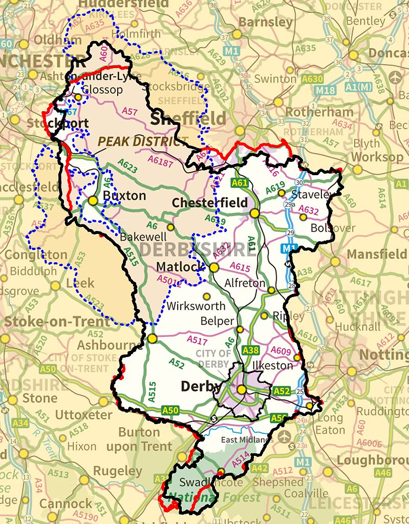
A large detailed map of Derbyshire, England
Explore Derbyshire with an interactive map featuring address search, nearby places, live weather, Street View and detailed location information. View satellite, terrain and road map layers across Derbyshire, England. Designed for fast access during travel planning and emergencies, including storms, flooding and severe weather.
Derbyshire County Map
Loading map…
Map search is available for a limited number of queries per session to manage costs. Be specific — search precisely for best results.
Derbyshire Maps
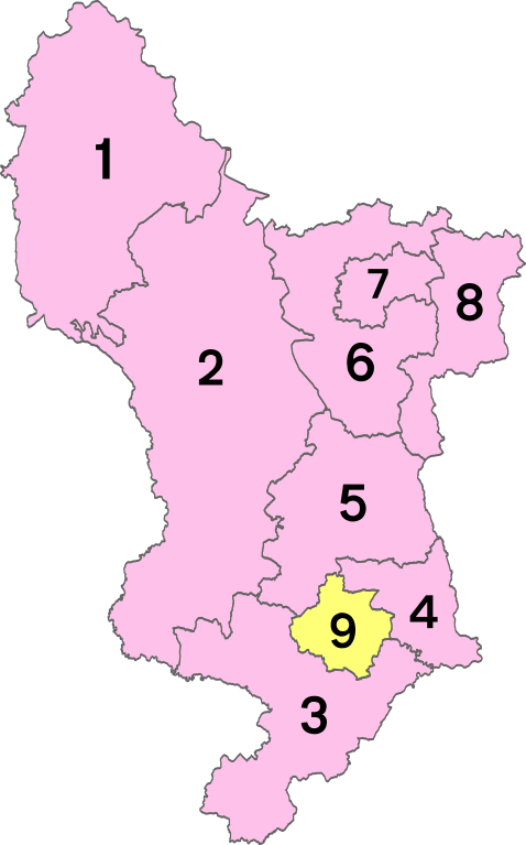
Districts of Derbyshire
1 - High Peak
2 - Derbyshire Dales
3 - South Derbyshire
4- Erewash
5 - Amber Valley
6 - North East Derbyshire
7 - Chesterfield
8 - Bolsover
9 - City of Derby
Derbyshire City and Town Maps
A
Abney | Acre Ridge Estate | Alderwasley | Aldwark | Alfreton | Alkmonton | Allestree | Alport | Alsop en le Dale | Alton | Alvaston | Ambaston | Ambergate | Apperknowle | Arkwright Town | Arthurs View | Ashbourne | Ashford in the Water | Ashgate | Ashgate | Ashleyhay | Ashover | Ashover Hay | Aston | Aston | Aston Heath | Aston-on-Trent | Astwith | Atlow | Ault Hucknall
B
Bacon's Spring | Bagshaw | Bakewell | Ballidon | Bamford | Bankwood Gate | Barber Booth | Bargate | Barlborough | Barlow | Barrow Hill | Barrow upon Trent | Barton Blount | Baslow | Batham Gate | Beeley | Bellevue | Belper | Belper Lane End | Belph | Biggin | Biggin | Birch Vale | Birchover | Birdholme | Birley | Birleyhay | Blackbrook | Blackbrook | Blackwell | Blackwell | Bole Hill | Bolehill | Bolehill | Bolsover | Bolsover Woodhouse | Bonsall | Boothgate | Borrowash | Boulton | Bowden Head | Bowshaw | Boylestone | Boythorpe | Brackenfield | Bradbourne | Bradley | Bradwell | Brailsford | Bramley | Brampton | Brand Side | Brassington | Breadsall | Breadsall Hilltop | Breaston | Breckend | Bretby | Bretton | Bridge End | Bridgehill | Bridgemont | Brightgate | Brimington | Brimington Common | Broadmeadows | Brockhurst | Brockwell | Brook Bottom | Brookfield | Brookside | Brough | Bubnell | Buckland Hollow | Bullbridge | Burbage | Burnaston | Burntheath | Burrfields | Butterley | Butterley | Buxton | Buxworth
C
Caldwell | Calke | Callow | Calow | Calow | Calton Lees | Calver | Calver Low | Calver Sough | Carr Vale | Carsington | Cartledge | Castle Gresley | Castle View | Castleton | Chaddesden | Chapel Milton | Chapel-en-le-Frith | Charlestown | Charlesworth | Chellaston | Chelmorton | Chesterfield | Chevinside | Chinley | Chisworth | Chunal | Church Broughton | Church Gresley | Church Hill | Church Town | Church Wilne | Churchbalk | Churchtown | Cinderhill | Clay Cross | Cliffside | Clifton | Clowne | Coal Aston | Cock Alley | Cockyard | Coddington | Codnor | Codnor Gate | Combs | Common Side | Common Side | Commonside | Compton | Congreave | Conksbury | Coplow Dale | Corbriggs | Cotes Park | Cotmanhay | Coton in the Elms | Cowdale | Cowers Lane | Cowhill | Cowley | Coxbench | Cressbrook | Creswell | Crewton | Crich | Cromford | Cropper | Cross Hill | Cross o' th' hands | Crowden | Crowdicote | Crowhole | Cubley Common | Culland | Curbar | Cutthorpe
D
Dalbury | Dalbury Hollow | Dale Abbey | Dale End | Dalebank | Danesmoor | Darley Abbey | Darley Bridge | Darley Dale | Denby Bottles | Denby Common | Denby Village | Derby | Derby War Memorial Village | Dethick | Dicklant | Dimple | Dinting Vale | Doe Lea | Doehole | Dove Head | Dove Holes | Doveridge | Dowry | Draycott | Dronfield | Dronfield Woodhouse | Duckmanton | Duffield | Duffieldbank | Dunsa | Dunston
E
F
G
Gallows Inn | Gamesley | Glapwell | Glossop | Godfreyhole | Golden Valley | Gorsey Leys | Gorseybank | Gosforth Valley | Grangemill | Grassmoor | Great Cubley | Great Hucklow | Great Longstone | Great Wilne | Greenhillocks | Greenside | Greenwich | Grindleford | Grindlow
H
Hadfield | Hady | Hague Bar | Hales Green | Hallam Fields | Hammersmith | Handley | Hangingbridge | Hardstoft | Hardwick | Hardwick Wood | Hare Edge | Harehill | Hargatewall | Harper Hill | Harpur Hill | Hartington | Hartshorne | Hasland | Hassop | Hathersage | Hathersage Booths | Hatton | Hatton Fields | Hayfield | Hazelwood | Heage | Heanor | Heanor Gate | Heath | Heath End | Heathcote | Heathtop | Hemming Green | Henmoor | Hidebank | High Cross Bank | High Lee | High Peak Junction | Higham | Higher Buxton | Higher Chisworth | Higher Crossings | Higher Dinting | Higher Gamesley | Highgate | Hilcote | Hill Somersal | Hill Top | Hillclifflane | Hillstown | Hilltop | Hilton | Hockerley | Hodthorpe | Hognaston | Holbrook | Hollington | Hollingwood Estate | Hollins | Hollins Green | Holloway | Holmesdale | Holmesfield | Holmewood | Holmgate | Holmley Common | Holymoorside | Hope | Hopton | Horsley | Horsley Woodhouse | Horsleygate | Horwich End | Hulland Village | Hulland Ward | Hundall
I
Ible | Idridgehay | Ilkeston | Ilkeston Junction | Ingleby | Ingmanthorpe | Inkersall Green | Ireton Wood | Ironville
K
Kedleston | Kelstedge | Kilburn | Killamarsh | King Sterndale | King's Newton | Kirk Hallam | Kirk Ireton | Kirk Langley | Kniveton | Knockerdown
L
Ladmanlow | Ladygrove | Lane Ends | Lane Head | Langley | Langley Common | Langley Mill | Langwith | Langwith Junction | Larklands | Lea | Leabrooks | Leaden Knowl | Leadmill | Lee Head | Lees | Lightwood | Lilypool | Limekiln Field | Linton | Linton Heath | Litchurch | Little Chester | Little Cubley | Little Eaton | Little Hallam | Little Hayfield | Little Hucklow | Little Longstone | Littlemoor | Littleover | Litton | Lodge House Surface Mine | Lodge House Surface Mine | Long Duckmanton | Long Eaton | Longcliffe | Longford | Longlane | Loscoe | Loundsley Green | Low Leighton | Lower Birchwood | Lower Crossings | Lower Dinting | Lower Gamesley | Lower Hartshay | Lower Kilburn | Lower Midway | Lower Pilsley | Lower Thurvaston | Lowgates | Lullington | Lumsdale | Lydgate
M
Mackworth | Mackworth Estate | Makeney | Malcoff | Mapleton | Mapperley | Marehay | Markeaton | Markham Vale | Marlpool | Marsh Lane | Marston Montgomery | Marston on Dove | Mastin Moor | Matlock | Matlock Bank | Matlock Bath | Matlock Bridge | Matlock Dale | Matlock Green | Melbourne | Mercaston | Mickleover | Mickley | Mickley | Middle Handley | Middlecroft | Middleton | Middleton | Milehill | Milford | Mill Green | Millers Dale | Millers Green | Millington Green | Millthorpe | Milltown | Milton | Monsal Head | Monyash | Moorend | Moorhall | Moorwood Moor | Morley | Morley | Morley Smithy | Morleymoor | Morton | Mount Pleasant | Mount Pleasant | Mount Pleasant | Mugginton | Muggintonlane End
N
Nether Biggin | Nether Booth | Nether Chanderhill | Nether End | Nether Green | Nether Handley | Nether Heage | Nether Loads | Nether Moor | Nether Padley | Nether Sturston | Netherseal | Netherthorpe | Netherthorpe | New Bolsover | New Brimington | New Horwich | New Houghton | New Mills | New Sawley | New Smithy | New Stanton | New Whittington | New York | New Zealand | Newbold | Newbold Moor | Newgate | Newhall | Newhaven | Newlands | Newmarket | Newton | Newton Solney | Newtown | Nithen End | Norbury | Normanton | North Wingfield | Northedge | Northwood | Norwood | Nuttals Park
O
Oaker | Oakerthorpe | Oaks Green | Oakwood | Ockbrook | Offerton | Ogston | Old Brampton | Old Glossop | Old Matlock | Old Tupton | Old Whittington | Osleston | Osmaston | Osmaston | Over Burrows | Over End | Over Haddon | Over Leigh | Overseal | Oversetts | Overton | Owler Bar | Oxcroft | Oxcroft Estate
P
Padfield | Palterton | Park Head | Park Nook | Parsley Hay | Parwich | Peak Dale | Peak Forest | Peakley Hill | Pear Tree | Peasehill | Pentrich | Pentrichlane-end | Pikehall | Pilhough | Pilsbury | Pilsley | Pilsley | Pinxton | Plaistow | Plaistow Green | Pleasley | Pleasley Vale | Pomeroy | Poolsbrook | Porterhouse | Pratthall | Press | Priestcliffe | Priestcliffe Ditch | Pye Bridge
Q
R
Radbourne | Radbourne Common | Ravensnest | Rawson Green | Renishaw | Repton | Riber | Riddings | Riddings | Ridgeway | Ridgeway | Ripley | Risley | River's Vale | Robin Hood | Rodsley | Rose Hill | Rosliston | Roston | Rowarth | Rowland | Rowsley | Rowthorne | Rumbling Street | Rylah
S
Sandiacre | Sapperton | Sawley | Sawmills | Scarcliffe | Scotches | Scropton | Shardlow | Shatton | Shaw | Sheepbridge | Sheldon | Shelton Lock | Shepley Street | Shipley | Shipley Common | Shirebrook | Shireoaks | Shirland | Shirley | Short Heath | Shottle | Shottlegate | Shuttlewood | Simmondley | Sinfin | Slack | Slackhall | Slaley | Smalldale | Smalldale | Smalley | Smalley Green | Smisby | Smithfield | Smithy Moor | Snape Hill | Snelston | Snelston Common | Snitterton | Somercotes | Somersal Herbert | South Normanton | South Wingfield | Spancarr | Sparrowpit | Spinkhill | Spital | Spitalhill | Spitewinter | Spondon | Spout | St Augustines | Staden | Stainsby | Stainsby Common | Stanfree | Stanhope Bretby | Stanley | Stanley Common | Stanton | Stanton Gate | Stanton Lees | Stanton by Bridge | Stanton in Peak | Stanton-by-Dale | Starkholmes | Staveley | Steeple Grange | Stenson | Sterndale Moor | Stockley | Stoke | Stone Edge | Stonebroom | Stonegravels | Stoneheads | Stoney Middleton | Stoneyford | Stony Houghton | Street Lane | Stretton | Sudbury | Summerley | Summerwood Top | Sunny Hill | Sutton Scarsdale | Sutton on the Hill | Swadlincote | Swanwick | Swarkestone
T
Taddington | Tansley | Tapton | Taxal | Temple Normanton | The Brushes | The Bungalows | The Elms | The Gutter | The Holmes | The Leys | The Park | Thornhill | Thornsett | Thorpe | Thulston | Thurvaston | Thurvaston | Tibshelf | Ticknall | Tideswell | Tinkersley | Tintwistle | Tissington | Toadhole Furnace | Toadmoor | Tomthorn | Torr Top | Townend | Trentlock | Troway | Trusley | Tunstead | Tunstead Milton | Tupton | Turnditch | Two Dales | Twyford
U
Unstone | Unstone Green | Unthank | Upper Biggin | Upper Booth | Upper End | Upper Hackney | Upper Hartshay | Upper Langwith | Upper Loads | Upper Midway | Upper Newbold | Upper Padley | Upper Town | Upper Town | Upper Town | Upperthorpe | Uppertown | Upperwood
W
Wadshelf | Waingroves | Wakebridge | Waldley | Walton | Walton-on-Trent | Wardlow | Wardlow Mires | Warmbrook | Warrencarr | Wash | Washgreen | Wensley | Wessington | West Broughton | West End | West Hallam | West Handley | Westhouses | Weston Underwood | Weston-on-Trent | Westthorpe | Whaley | Whaley Bridge | Whaley Thorns | Whatstandwell | Wheatcroft | Wheston | White Moor | Whitehough | Whitehough Head | Whitfield | Whitfield Park | Whittington Moor | Whitwell | Whitwell Common | Wigley | Wilday Green | Williamthorpe | Willington | Wilmorton | Windley | Windmill | Wingerworth | Winsick | Winster | Wirksworth | Woodhead | Woodlinkin | Woodnook | Woodseats | Woodthorpe | Woodville | Woolley | Woolley Moor | Wormhill | Wyaston