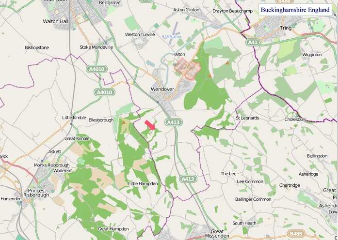
A large detailed map of Buckinghamshire, England
Explore Buckinghamshire with an interactive map featuring Street View, satellite and terrain views. Live weather, local news and location details for Buckinghamshire — plus links to detailed street maps for cities, towns, villages and hamlets across the county.
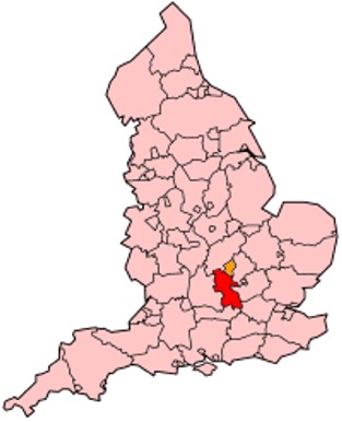
Buckinghamshire County Map
Map search is available for a limited number of queries per session to manage costs. Be specific — search precisely for best results.
| County Town | Aylesbury |
| Region | South East England |
| Country | England |
| Status | Ceremonial county |
| Area | 1,874 km² |
| Population | 560,000 |
| Latitude | 51.8368 |
| Longitude | -0.7778 |
| Cities & Towns | 573 |
| Locality Maps | Locality Maps |
About Buckinghamshire
Gentle undulations define Buckinghamshire’s terrain, a landscape painted in muted greens and earthen browns, far from the rugged drama of the northern shires. The Chiltern Hills, a verdant spine, rise with a quiet dignity, their beech woods whispering ancient secrets on the breeze, while the placid Thames forms a southern boundary, its waters reflecting the stately homes and willow-draped banks. Brooks and streams, like the Ouzel and the Thame, thread their way through valleys, feeding the fertile soil that has shaped the county’s character for millennia. This is a land of hedgerows and quiet lanes, where nature's hand is evident but seldom ostentatious, a gentle embrace rather than a forceful declaration.
Echoes of Roman legions and Saxon settlements resound through Buckinghamshire's past, a tapestry woven with threads of conquest and continuity. Verulamium, though now a shadow, testifies to imperial ambitions, while later Norman lords erected formidable castles, such as those at Wendover and Hambleden, to secure their dominion. The county played its part in the Wars of the Roses and witnessed the Civil War's fierce passions, with skirmishes and sieges leaving their mark on its ancient market towns. More recently, its strategic position has seen it evolve from a rural heartland to a hub of innovation and commerce, a testament to its enduring adaptability.
Agriculture has long been the bedrock of Buckinghamshire’s economy, its chalky soils yielding abundant crops and supporting hardy livestock, a tradition that persists in the rolling pastures around Aylesbury. Yet, the county’s industrial prowess has diversified considerably, with manufacturing enterprises, particularly in engineering and pharmaceuticals, flourishing in towns like High Wycombe and Amersham. Today, its proximity to London fuels a vibrant service sector, and the presence of significant global corporations signals a modern economic vitality, a far cry from the agrarian simplicities of bygone eras.
A quiet resilience and a deep-rooted sense of community characterise the people of Buckinghamshire, a spirit reflected in their traditions of local governance and enduring village life. The county has nurtured figures of note, from the poet John Milton, who found inspiration in its environs, to the political orator Edmund Burke, whose eloquence shaped national discourse. Its artistic heritage is subtle, often found in the craftsmanship of its furniture makers and the enduring appeal of its historic churches, a testament to a way of life that values both tradition and understated progress.
Buckinghamshire Maps
"© OpenStreetMap contributors, CC BY-SA".
Districts of Buckinghamshire
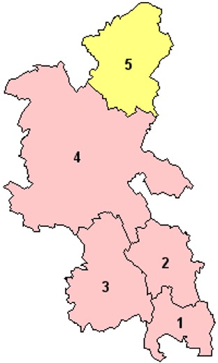
1 - South Bucks
2 - Chiltern
3 - Wycombe
4 - Aylesbury Vale
5 - Milton Keynes
From Wikipedia, the free encyclopedia
Buckinghamshire City and Town Maps
A
B
C
D
E
F
G
H
I
J
K
L
M
N
O
P
Q
R
S
T
W
Buckinghamshire Maps — Interactive Map, Street View, Weather & News
This page provides an interactive Google map of Buckinghamshire, England with Street View, satellite and terrain views, alongside links to detailed street maps for cities, towns, villages and hamlets across the county. Buckinghamshire sits within the South East England region.
Every locality map page includes an embedded street and satellite map together with live weather where available — current conditions with hourly and 7-day outlooks powered by Open-Meteo. Local and world news feeds — including BBC News — keep pages current, and Wikipedia summaries provide additional local context.
Location data is sourced from OS Open Names © Crown copyright and database rights 2024, Ordnance Survey, Open Government Licence v3.0, and verified by coordinates rather than name matching alone.